 Geus Geonetworks metadata catalogue
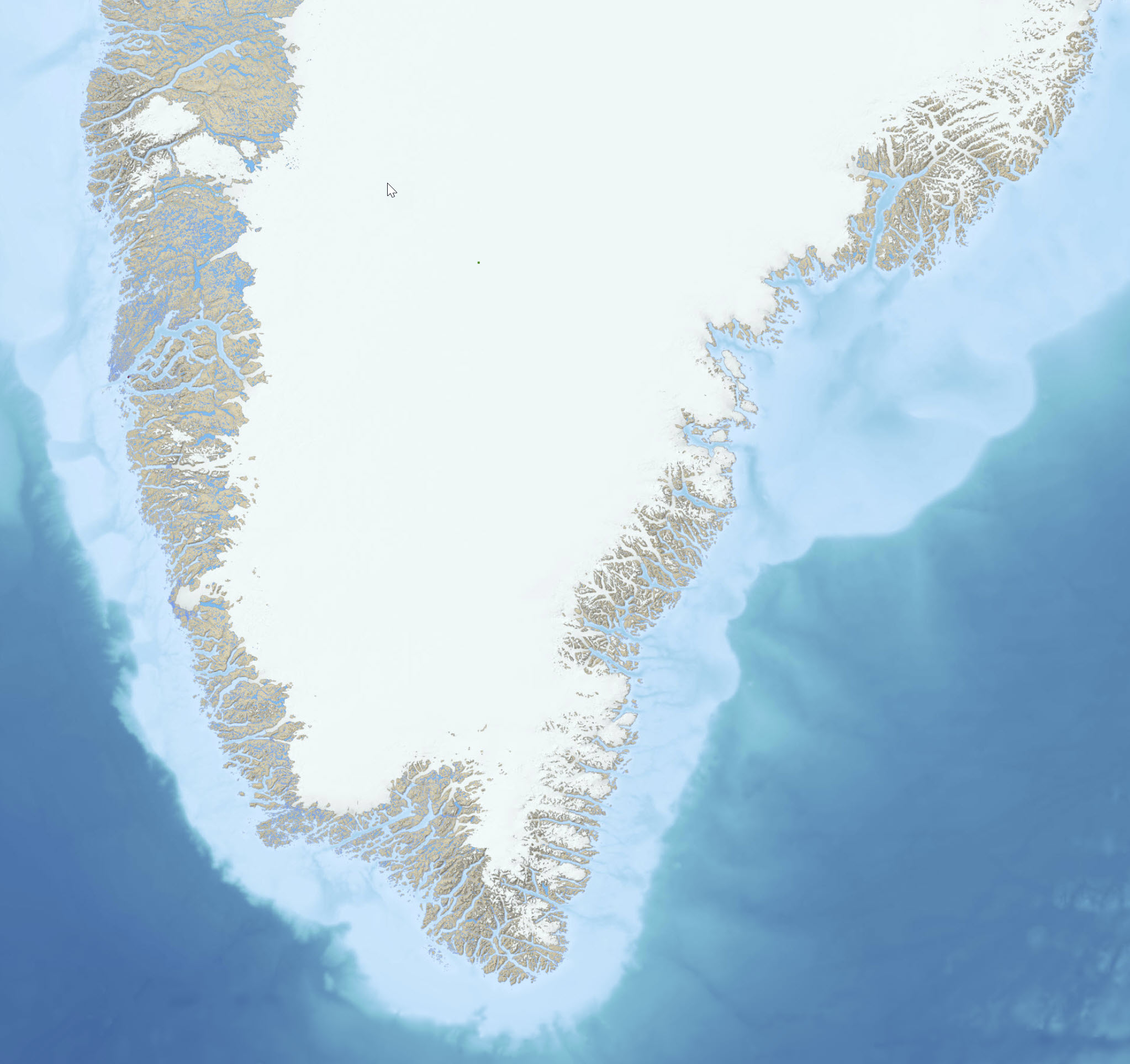
Topographic map of Greenland 1:250 000
The topographic map of Greenland 1:250.000 are based on data collected in the 1930s and 1970-80s, which led to the production of a series of 1:250.000 scale topographic sheets, which remain the basic mapping for most of the dataset. Maps covering the area prior to 1970 were compiled in 18 sheets at 1:300.000 scale for North Greenland by Lauge Kock (1932, 1940), part of Northeast Greeland at 1:250.000 in the 1930s by the Geodetic Institute (now Danish Agency for Data Supply and Infrastructure (SDFI)), and the entire region at 1:250.000 by the American Army Map Services in the 1950s.
The digital topographic map of North and Northeast Greenland has been provided by the Geological Survey of Denmark and Greenland (GEUS) from 1977 based on high precision digital photogrammetry in the study of aerial photographs of Greenland for compiling geological data at map scales of 1:100.000 and 1:500.000. Details are described in the report Digital Topographic Map of North and Northeast Greenland Vol. 2003, No. 89), https://doi.org/10.22008/gpub/25368.
The production of the digital maps was undertaken by the Geological Survey of Denmark and Greenland and was supervised by a steering committee that included representatives from Ministry of Environment and Nature, Nuuk; Bureau of Minerals and petroleum (BMP), Nuuk; Asiaq, Nuuk; the National Survey and Cadastre, Copenhagen; and the National Environmental Research Institute; Roskile.
Simple
- Date (Revision)
- 2023-03-24
- Identifier
- dk.geus: / g250_topographic_map
- Presentation form
- Digital map
- Purpose
- The digital topographic map of Greenland has been complied for the needed modern topographic data in the production of geological data at map scales of 1:100.000 and 1:500.000.
- Status
- Completed
- Maintenance and update frequency
- As needed
- GEMET - INSPIRE themes, version 1.0
-
- Geology
- Elevation
- Buildings
- Geographical names
- Land cover
- Keywords
-
- Continents, countries, sea regions of the world.
-
- Greenland
- Access constraints
- Copyright
- Use constraints
- Copyright
- Other constraints
- No limitations on public access
- Other constraints
- Conditions for Re-use of data https://data.geus.dk/geusmap/terms_20140620.pdf
- Spatial representation type
- Vector
- Denominator
- 250000
- Distance
- -1 m
- Metadata language
- English
- Topic category
-
- Geoscientific information
- Imagery base maps earth cover
- Elevation
- Location
))
- Reference system identifier
- EPSG / https://epsg.io/32624
- Geometric object type
- Complex
- Distribution format
-
-
Web Service
(
2.0
)
-
Web Service
(
2.0
)
- OnLine resource
-
Interactive map
(
WWW:LINK-1.0-http--link
)
Greenland Portal
- OnLine resource
-
Basemaps_G250_Topographic_Map_UTM24N
(
OGC:WMTS
)
Basemaps_G250_Topographic_Map_UTM24N
- OnLine resource
- Topographic Map of Greenland 1:250.000 ( ESRI:REST )
- OnLine resource
-
Digital Topographic Map of North and Northeast Greenland (1 CD-Rom included)
(
WWW:LINK-1.0-http--link
)
Jepsen, H. F., Mikkelsen, N. E., Platen-Hallermund, F. V., Schjøth, F. O., & Weng, W. L. (2003). Digital Topographic Map of North and Northeast Greenland (1 CD-Rom included). (Danmarks og Grønlands Geologiske Undersøgelse Rapport; Vol. 2003, No. 89). GEUS. https://doi.org/10.22008/gpub/25368
- Hierarchy level
- Dataset
Conformance result
- Date (Publication)
- 2010-12-08
- Explanation
- This field has no significance
- Pass
- No
- Statement
-
The Geodetic Institute of Denmark began surveying the settled coastal areas in 1927 which led to the production of a series of 1:250,000 scale topographic sheets, which remain the basic mapping for most of the island. A primary geodetic network was established based on an astronomical station at Qoornoq. Originally, map detail was provided by plane table survey, but from 1932 to 1938 an extensive air survey was made of the coastal areas from which photogrammetric compilation of subsequent sheets was made. By 1964, the ice-free areas of the country had all been photographed, and sheets have been completed for almost all these areas. Early sheets showed relief by hillshading, and contours with a brown tone for upland and green for lowland. Later sheets have a revised specification, with no relief shading, although a green tone is retained for lowland, and ice-free upland is shown in pale yellow. Contours are at 50 m intervals. The projection was in Lambert conformal conical with one standard parallel, or UTM, based on the international ellipsoid, and the datum, originally the Qoornoq Datum, was changed to North American Datum 1984. Place names are in Inuit and Danish. Sheets in the series each cover 1° of latitude, with west coast sheets identified by a prefix V and east coast with a prefix Ø. Revision of these sheets is limited to important corrections.
The dataset is projected to WGS 1984 / UTM zone 24 North to accommodate the standard of all hosted datasets on the Greenland Mineral Resources Portal (www.greenmin.gl).
A hillshading has been provided based on the Greenland Ice sheet Mapping Project (GIMP) Digital Elevation Model. Data Citation: Howat, I.M., A. Negrete, B.E. Smith, 2014, The Greenland Ice Mapping Project (GIMP) land classification and surface elevation datasets, The Cryosphere, 8, 1509-1518, doi:10.5194/tc-8-1509-2014.
Bathymetry has been assigned to the map based on the General Bathymetric Chart of the Oceans (GEBCO) from 2019 by the GEBCO Compilation Group (2021) GEBCO 2021 Grid (doi:10.5285/c6612cbe-50b3-0cff-e053-6c86abc09f8f).
- File identifier
- f3c6c2e4-f161-4c42-83a4-b7acbd127980 XML
- Metadata language
- English
- Hierarchy level
- Dataset
- Date stamp
- 2025-02-27T13:50:21
- Metadata standard name
- ISO 19115:2003 / ISO 19139:2007
Overviews
Spatial extent
Provided by
