 Geus Geonetworks metadata catalogue
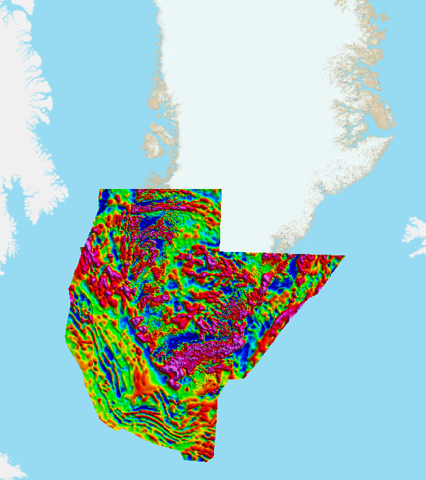
Greenland Magnetic compilation
The development of this new magnetic compilation from Greenland was initiated by the working group of Satellite- and Aerogeophysics at the Christian-Albrechts-University (CAU) in Kiel, Germany, and GEUS as part of the ESA project GOCE+Greenland in 2021. The total magnetic intensity anomaly map from South Greenland is the first part of a compilation that will be stepwise extended to cover whole Greenland including the Inland Ice and the adjacent shelf regions.
It is built out of all accessible modern regional aeromagnetic surveys from Greenland but also uses older datasets without GPS positioning in areas where modern data are lacking. Magnetic data are currently taken from the surveys of the AEROMAG and AEM projects (Rasmussen et al., 2013; Riisager & Rasmussen, 2014), GICAS project (e.g., Thorning et al., 1988), EASTMAR project (Larsen & Thorning, 1980), ICEBRIDGE project (see https://pgg.ldeo.columbia.edu/data/operation-icebridge ), GAP91/92 project (Brozena, 1992) and from offshore datasets acquired by the TGS-NOPEC TGS GEOPHYSICAL COMPANY. Since long wavelength components in aeromagnetic data are often considered as unreliable, they are replaced by the ones from the LCS-1 satellite model (Gaussian coefficients with degrees n = 13 – 133; Olsen er al., 2017).
The magnetic map is generated by a methodology that combines equivalent source modelling and a spherical harmonic expansion. The datapoints at their actual measuring locations are used as data input and magnetic dipoles are employed as equivalent sources that are arranged in three uniform grids with different source spacing and depths (coarsest spacing: 10 x 10 km; finest spacing: 0.7 x 0.7 km). The presented total magnetic intensity map is simulated from the dipole responses at a constant height of 2000 m asl and with a grid spacing of 700 x 700 m. Regularizations in the inversion for the different equivalent source grids are chosen such that the resulting resolution is flexible and adapted to the largely varying magnetic data coverage in Greenland.
A publication is in preparation that will provide more details about the data, methodology, implementation, and map quality.
How to cite: Björn H. Heincke, Wolfgang Szwilius, Judith Freienstein and Jörg Ebbing (2023). A new magnetic compilation from Greenland built by a combination of equivalent source modeling and spherical harmonic expansion. Greenland Portal, https://maps.greenmin.gl/geusmap/?mapname=greenland_portal&lang=en
References:
Brozena, J.M. (1992). The Greenland Aerogeophysics Project: Airborne Gravity, Topographic and Magnetic Mapping of an Entire Continent. In: Colombo, O.L. (eds) From Mars to Greenland: Charting Gravity with Space and Airborne Instruments. International Association of Geodesy Symposia, vol 110. Springer, New York, NY. https://doi.org/10.1007/978-1-4613-9255-2_19
Larsen, H., & Thorning, L. (1980). Project EASTMAR: acquisition of high sensitivity aeromagnetic data off East Greenland. Rapport Grønlands Geologiske Undersøgelse, 100, 91–94. https://doi.org/10.34194/rapggu.v100.7707
Olsen, N., Ravat, D., Finlay, C., & Kother, L. K. (2017). LCS-1: A high-resolution global model of the lithospheric magnetic field derived from CHAMP and Swarm satellite observations. Geophysical Journal International, 211(3), 1461–1477. https://doi.org/10.1093/gji/ggx381
Rasmussen, T. M., Thorning, L., Riisager, P. & Tukiainen, T. (2013). Airborne geophysical data from Greenland. Geology and Ore – Exploration and Mining in Greenland, No. 22 – February 2013, 12 pages. https://eng.geus.dk/media/13207/go22.pdf
Riisager, P., & Rasmussen, T. M. (2014). Aeromagnetic survey in south-eastern Greenland: project Aeromag 2013. GEUS Bulletin, 31, 63–66. https://doi.org/10.34194/geusb.v31.4662
Thorning, L., Bower, M., Hardwick, C., & Hood, P. (1988). Greenland ice cap aeromagnetic survey 1987: completion of the survey over the southern end of the Greenland ice cap. Rapport Grønlands Geologiske Undersøgelse, 140, 70–72. https://doi.org/10.34194/rapggu.v140.8039
Simple
- Date (Revision)
- 2022-01-01
- Identifier
- dk.geus: / Greenland Magnetic compilation
- Presentation form
- Digital map
- Purpose
- Airborne magnetic is considered as one of the cheapest and best suited geophysical method under remote arctic conditions and its surveys provide by far the densest coverage with geophysical data in Greenland. Magnetic data are the main source to extract geological information from the Inland Ice, but also provide essential information to understand the geological history of the ice-free coastal and adjacent shelf regions and is used e.g., for geological mapping, plate reconstruction and estimating heat flow, and are valuable for both mineral and hydrocarbon exploration.
- Status
- On going
- Maintenance and update frequency
- Irregular
- GEMET - INSPIRE themes, version 1.0
-
- Geology
- Keywords
-
- Greenland
- Aeromagnetic
- Satellite magnetic
- Total magnetic intensity
- Continents, countries, sea regions of the world.
-
- Greenland
- Access constraints
- Copyright
- Use constraints
- Copyright
- Other constraints
- The map can be published by agreement with GEUS. If the content of the magnetic map is used in scientific contributions, it should be cited as: "Björn H. Heincke, Wolfgang Szwilius, Judith Freienstein and Jörg Ebbing (2023). A new magnetic compilation from Greenland built by a combination of equivalent source modeling and spherical harmonic expansion. Greenland Portal, https://maps.greenmin.gl/geusmap/?mapname=greenland_portal&lang=en"
- Other constraints
- Conditions for Re-use of data https://data.geus.dk/geusmap/terms_20140620.pdf
- Spatial representation type
- Vector
- Spatial representation type
- Grid
- Denominator
- -1
- Distance
- 180 m
- Metadata language
- English
- Topic category
-
- Geoscientific information
))
- Reference system identifier
- EPSG / https://epsg.io/32624
- Geometric object type
- Complex
- Distribution format
-
-
Web Service
(
1.0
)
-
Web Service
(
1.0
)
- OnLine resource
- greenland portal ( WWW:LINK-1.0-http--link )
- Hierarchy level
- Dataset
Conformance result
- Date (Publication)
- 2010-12-08
- Explanation
- This field has no significance
- Pass
- No
- Statement
- Both data density and quality of the different used aeromagnetic datasets are strongly varying. The modern high-resolution AEROMAG and AEM surveys have inline spacing of 200-1000 m and good to excellent data quality. Older datasets as the GICAS and EASTMAR datasets were acquired without GPS positioning and some of these datasets were suffering also from a proper base station correction. Other datasets have only very coarse line spacing (GAP92/92) or consist of a pattern of irregularly flown profiles (ICEBRIDGE). Differences in the data quality of datasets are considered by assigning different error estimates in the inversion procedure of the equivalent source modelling. Variations in the data density are balanced by a properly chosen regularization in the equivalent source modelling.
- File identifier
- d632a262-3316-4c60-8c67-71fc53367334 XML
- Metadata language
- English
- Hierarchy level
- Dataset
- Date stamp
- 2024-08-26T10:15:35
- Metadata standard name
- ISO 19115:2003 / ISO 19139:2007
Overviews
Spatial extent
Provided by
