 Geus Geonetworks metadata catalogue
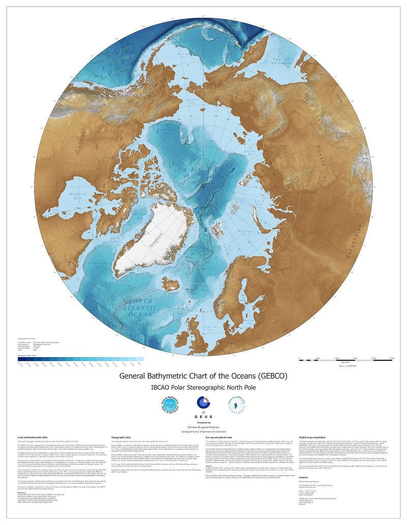
The General Batymetric Chart of the Oceans (2019) Polar Stereographic
The dataset contains the General Batymetric Chart of the Oceans (GEBCO) based on GEBCO_2019 Grid from 2019. The dataset has been projected to WGS 84 / IBCAO Polar Stereographic projection (EPSG:3996) and extends down to 50° latitude.
The complete data set provides global coverage, spanning 89° 59' 52.5''N, 179° 59' 52.5''W to 89°: 59' 52.5''S, 179° 59' 52.5''E on a 15 arc-second grid. It consists of 43200 rows x 86400 columns, giving 3,732,480,000 data points. The data values are pixel-centre registered i.e. they refer to elevations at the centre of grid cells.
The GEBCO_2019 Grid is a continuous, global terrain model for ocean and land with a spatial resolution of 15 arc seconds.
The grid uses as a ‘base’ Version 1 of the SRTM15+ data set (Olson et al, 2014). This data set is a fusion of land topography with measured and estimated seafloor topography. It is largely based on version 11 of SRTM30+ (Becker et al, 2009; Sandwell et al, 2014), augmented with the gridded bathymetric data sets developed by the four Seabed 2030 Regional Centers. The published data were recalculated on a cell-registered grid for use by GEBCO. The GEBCO_2019 Grid includes data sets from a number of international and national data repositories and regional mapping initiatives.
Simple
- Date (Publication)
- 2021-04-01
- Identifier
- dk.geus: / gebco_2019_polar_stereographic
- Presentation form
- Digital map
- Purpose
- Created specifically as a basemap for the ISAAFFIK arctic gatway partal and hosted on GEUS ArcGIS Servere as Web Map Tile Service (WMTS).
- Status
- Completed
- Maintenance and update frequency
- As needed
- GEMET - INSPIRE themes, version 1.0
-
- Geology
- Oceanographic geographical features
- Elevation
- Keywords
-
- GEBCO
- ISSAFFIK
- Bathymetry
- Continents, countries, sea regions of the world.
-
- North Pacific Ocean
- Greenland
- Greenland Sea
- Canada
- Arctic Ocean
- United States
- North Atlantic Ocean
- Access constraints
- Intellectual property rights
- Use constraints
- Copyright
- Other constraints
- GEBCO Compilation Group (2019) GEBCO 2019 Grid (doi:10.5285/836f016a-33be-6ddc-e053-6c86abc0788e)
- Other constraints
- Conditions for Re-use of data http://pubs.geus.net/et_dokument
- Spatial representation type
- Grid
- Denominator
- 100000
- Distance
- 100 m
- Metadata language
- English
- Topic category
-
- Geoscientific information
- Elevation
- Oceans
))
- Reference system identifier
- EPSG / 3996
- Geometric object type
- Surface
- Distribution format
-
-
Web Service
(
1.0
)
-
Web Service
(
1.0
)
- OnLine resource
-
Download
(
WWW:LINK-1.0-http--link
)
Official download site
- OnLine resource
-
Basemaps_GEBCO_2019_PolarStereo
(
OGC:WMTS-1.0.0-http-get-capabilities
)
Basemap for the General Batymetric Chart of the Oceans (2019) in Polar Stereographic.
- Hierarchy level
- Dataset
Conformance result
- Date (Publication)
- 2010-12-08
- Explanation
- This field has no significance
- Pass
- No
- Statement
-
The GEBCO_2019 Grid is released by the General Bathymetric Chart of the Oceans (GEBCO) and has been developed through the Nippon Foundation-GEBCO Seabed 2030 Project with all rights reserved. The Seabed 2030 Project aims to bring together all available bathymetric data to produce the definitive map of the world ocean floor and make it available to all.
The GEBCO_2019 product provides global coverage with a continuous, global terrain model for ocean and land with a spatial resolution of 15 arc-seconds grid. It consists of 86400 rows x 43200 columns, giving 3,732,480,000 data points. The data values are pixel-center registered i.e. they refer to elevations at the center of grid cells.
The grid uses as a ‘base’ Version 1 of the SRTM15+ data set (Olson et al, 2014). This data set is a fusion of land topography with measured and estimated seafloor topography. It is largely based on version 11 of SRTM30+ (Becker et al, 2009; Sandwell et al, 2014), augmented with the gridded bathymetric data sets developed by the four Seabed 2030 Regional Centers. The published data were recalculated on a cell-registered grid for use by GEBCO.
The majority of the work, for the non-polar regions, was done using the 'remove-restore' procedure (Smith and Sandwell, 1997; Becker, Sandwell and Smith, 2009 and Hell and Jakobsson, 2011). This is a two-stage process of computing the difference between the new data and the 'base' grid, gridding the difference and adding this difference back to the existing base grid. The aim is to achieve a smooth transition between the 'new' and 'base' data sets with the minimum of perturbation of the existing base data set.
For the polar data sets, and the adjoining North Sea, are supplied in the form of complete grids. These data sets were included using feather blending techniques from GlobalMapper software version 11.01, made available by Blue Marble Geographic.
- File identifier
- 9a83231b-1586-444a-b38f-b8eb983c45e7 XML
- Metadata language
- English
- Hierarchy level
- Dataset
- Date stamp
- 2023-10-10T15:08:27
- Metadata standard name
- ISO 19115:2003 / ISO 19139:2007
Overviews
Spatial extent
Provided by
