 Geus Geonetworks metadata catalogue
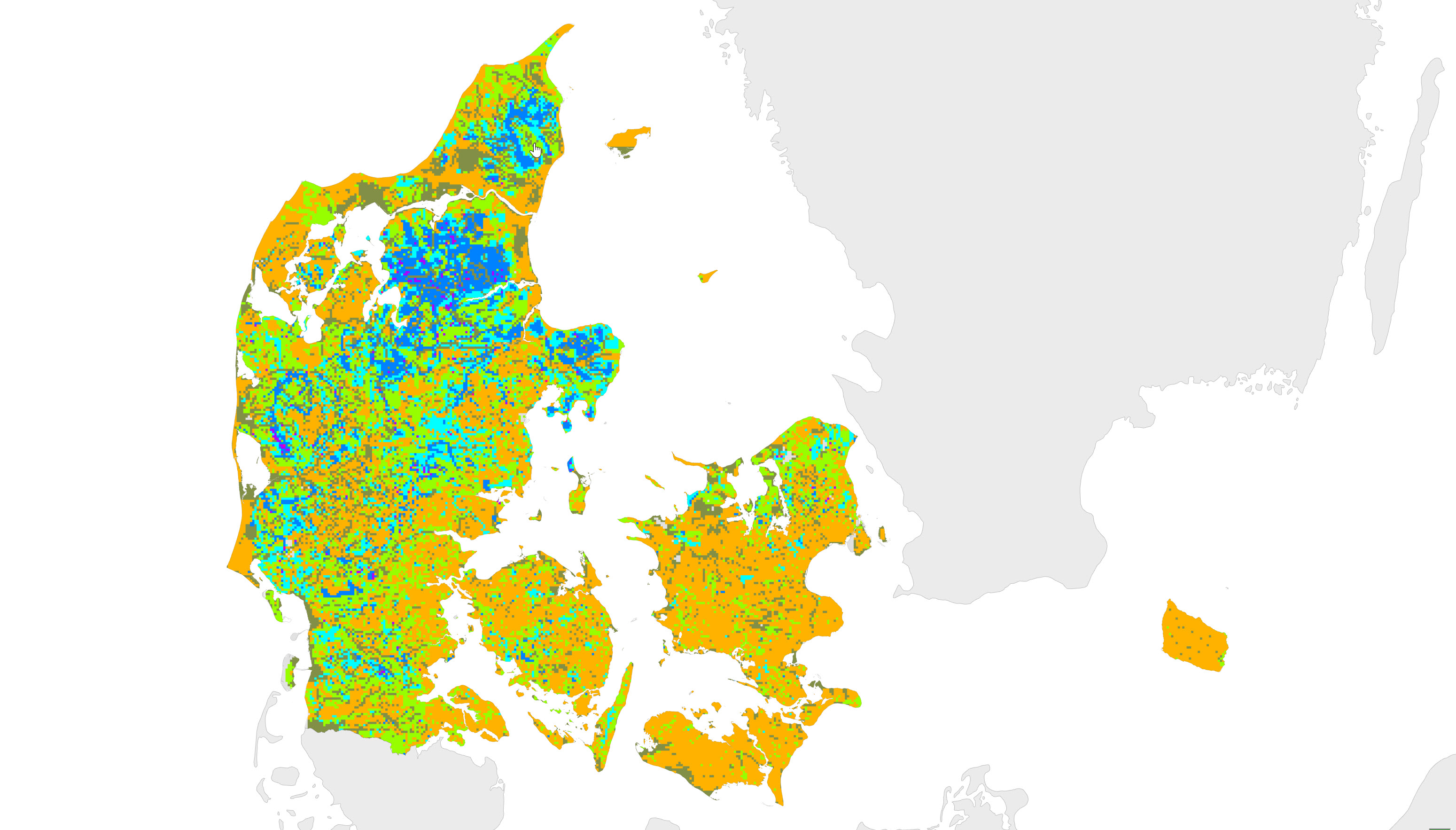
Depth to redox boundary in the subsurface of Denmark, 1 km grid
This map is the first national map showing the depth in meters to the uppermost redox interface in sediments of Quaternary age. The redox interface indicates the transition from the oxidized to the reduced geochemical environment in sediments. The redox interface was identified according to the colors of the sediments in 11,999 wells and is shown for 1x1 km grid-cells. For grid-cells with multiple site information, the depth to the redox interface is indicated by an average value. For grid-cells without any field information, the depth of the redox interface was established based on information about 1) geological setting, 2) morphology, 3) depths to redox boundaries at nearby field sites, 4) GEUS surface geology map, 5) topography, and 6) the pre-quaternary surface.
The method for this first national redox-map and the data used is described in GEUS report no. 93 (2006) entitled Beregning af nitrat-reduktionsfaktorer for zonen mellem rodzonen og frem til vandløbet. Data og metode for 1.generationskortet (in Danish). The Redox map is also described in Vand og Jord (2011) 18: 37-39 (in Danish).
Simple
- Date (Revision)
- 2019-03-12
- Identifier
- dk.geus: / Redox dybde 1km grid
- Presentation form
- Digital map
- Purpose
- The map shows the value of the redox limit in meters below ground. The redox boundary is defined as the transition between soil layers that are oxidized to soil layers where reduced conditions occur. On the basis of approx. 13,000 observations of color change in sediment samples, a model has been developed that describes the relationship between various explanatory variables and the depth to the redox limit. The machine learning method "Random Forest" is used for the model, and a spatial grid resolution of 100 m is used. The map shows the best estimate of the depth to the redox limit.
- Status
- Completed
- Maintenance and update frequency
- As needed
- GEMET - INSPIRE themes, version 1.0
-
- Geology
- Land cover
- Soil
- Keywords
-
- Redox
- Nitrat
- Ground water
- Access constraints
- Copyright
- Use constraints
- Copyright
- Other constraints
- The map may be published with the consent of GEUS.
- Other constraints
- Conditions for re-use of data https://data.geus.dk/geusmap/terms_20140620.pdf
- Spatial representation type
- Grid
- Denominator
- 500000
- Distance
- 1000 m
- Metadata language
- dan
- Topic category
-
- Geoscientific information
- Environment
- Inland waters
))
- Reference system identifier
- EPSG / https://epsg.io/25832
- Geometric object type
- Complex
- Distribution format
-
-
Web Service
(
1.3.0
)
-
Web Service
(
1.3.0
)
- OnLine resource
-
Denmark's Geology Portal
(
WWW:LINK-1.0-http--link
)
GEUS' web portal for geological maps of Denmark
- OnLine resource
-
Download
(
WWW:DOWNLOAD-1.0-http--download
)
Download datasets from GEUS' Dataverse
- OnLine resource
-
Webservice
(
OGC:WMS-1.3.0-http-get-capabilities
)
Web service for the dataset
- OnLine resource
-
The first nationwide redox map
(
WWW:LINK-1.0-http--link
)
Ernstsen, V., Jakobsen, P. R. & von Platen, F., Nov 2010, In: Vand & Jord. 17, 4, p. 159-160 2 p.
- Hierarchy level
- Dataset
Conformance result
- Date (Publication)
- 2010-12-08
- Explanation
- This field has no significance
- Pass
- No
- Statement
- The map was prepared by Vibeke Ernstsen, Peter Roll Jacobsen and Frants von Platen in 2006. The map was part of the data basis for the guidance for use by the municipalities' administration of applications for establishment, changes and expansions of livestock farms.
- File identifier
- 886130fd-142f-4883-b291-29e47ba57148 XML
- Metadata language
- dan
- Hierarchy level
- Dataset
- Date stamp
- 2023-11-01T14:37:47
- Metadata standard name
- ISO 19115:2003 / ISO 19139:2007
Overviews
Spatial extent
Provided by
