 Geus Geonetworks metadata catalogue
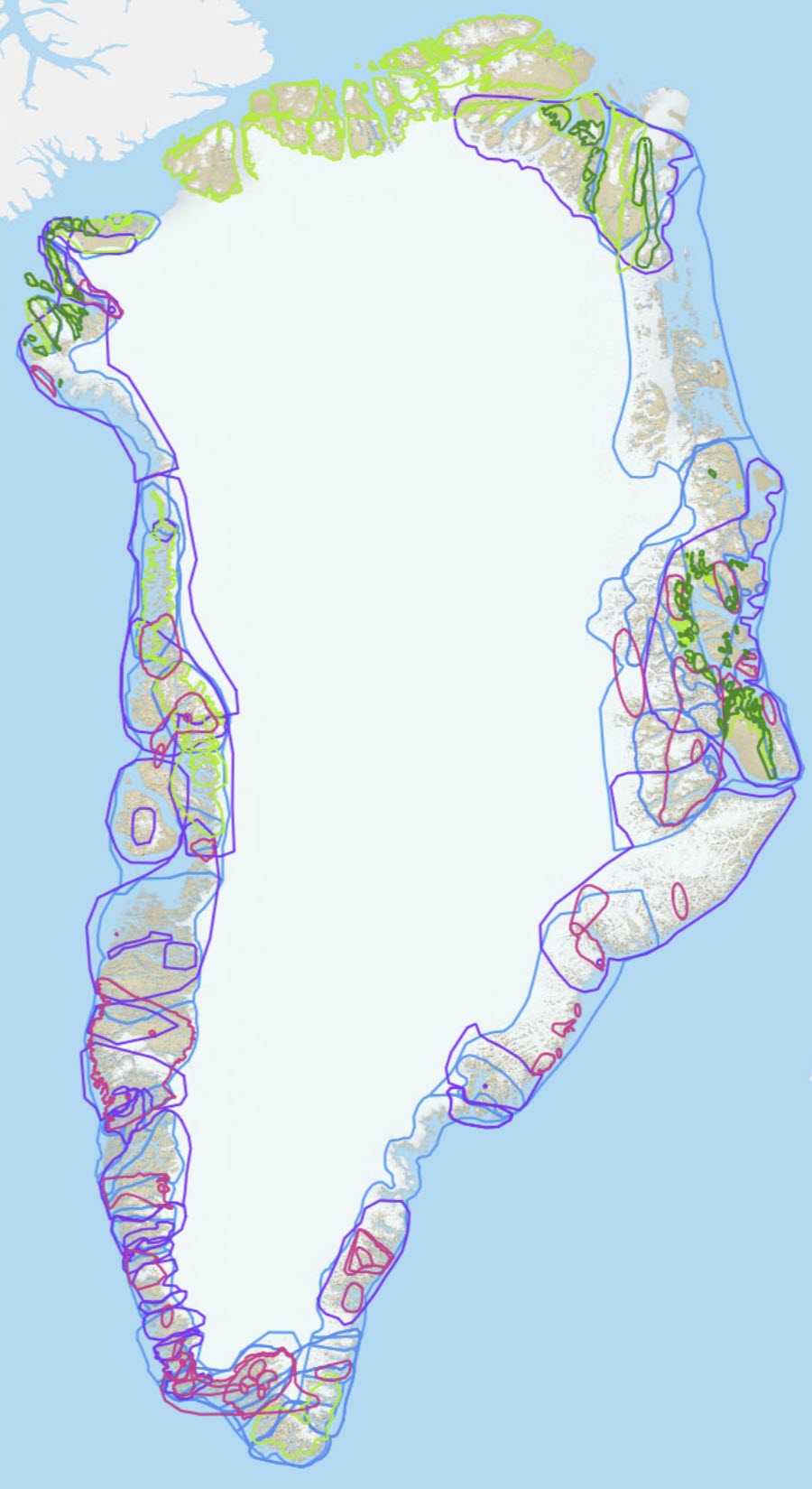
Greenland Mineral Resource Assessment Tracts
Greenland mineral assessment workshops have been held on Sedimentary-hosted Copper, type: redbed-, revett- and reduced-facies type in 2009, Various Rare Earth Elements deposit types in 2010 (this workshop was not carried out according to the 'three-part quantitative assessment' method), Sedimentary-hosted zinc SEDEX- and MVT-type in 2011, Magmatic nickel; komatiite-hosted, contact- and conduit-type in 2012 and Vein- and skarn type Tungsten in 2013 and Orogenic gold type in 2014.
Most of the workshops, besides the one on rare earth elements, have been following the processes and methodologies used in the 'three-part quantitative assessment' method of the U.S. Geological Survey described by Singer (1993). The method does not define deposits or provide mineral resource or reserve estimates according to industrial or international recognised certified standards. The objective is to produce a probabilistic estimate of unknown/undiscovered deposits and corresponding probabilistic estimates of the total amount of metals down to one kilometre depth. The estimates do not take into account economic, technical, social or environmental factors.
In the 'three-part quantitative assessment' method, an expert panel reviewed and discussed all available knowledge and data for a specific region (Tract) to assess the possibility of finding new undiscovered deposits within this Tract. The expert panels consisted of geologists from universities, research institutions, Surveys as well as private exploration and mining companies. The experts have either expertise in/worked with the deposit type in focus, with the regional and/or local geology relevant for the tracts being assessed or have expertise from exploration/mining projects for the deposit type in focus elsewhere in the world. One or two international top-experts on the mineral deposit type in focus for the different workshops have also participated in the workshop. After reviewing the available knowledge and data the members of the panel made their individual estimates (bids) of the number of undiscovered deposits they believed could be found under the best circumstances in a tract. The bids are based on the characteristics derived from descriptive mineral deposit models and a number of key-literature on the mineralisation type. In several of the workshops, critical elements have also been considered in the mineralising system (e.g. McCuaig & Hronsky 2014) associated with the deposit type in focus, when carrying out the bids. A panel discussion of the bids led to a consensus bid, which was used as input to a statistical Monte Carlo simulation. Based on established grade-/tonnage models of e.g. known tungsten deposits worldwide, this simulation can provide a prediction on how much undiscovered metals could be found within a Tract.
The 'Tracts' are spatial polygons that define a certain area that was found to be permissive for the concerned mineral deposit type and which constitutes the same level of geology, knowledge and data coverage. Tracts are named with a unique name, tract area is given in square kilometre and consensus bids from team under N90, N50, N10, N05 and N01 headings of undiscovered metals deposits at different confidence levels. The statistics from the Monte Carlo simulation is shown under the headings Numbers of unknown deposits and Deposit density.
Simple
- Date (Revision)
- 2022-01-01
- Identifier
- dk:geus: / mineral_assessment_tracts
- Presentation form
- Digital map
- Status
- Completed
- Maintenance and update frequency
- As needed
- GEMET - INSPIRE themes, version 1.0
-
- Geology
- Mineral resources
- Keywords
-
- Copper
- Nickel
- Gold
- Rare earth Elements
- Tungsten
- Continents, countries, sea regions of the world.
-
- Greenland
- Access constraints
- Copyright
- Use constraints
- Copyright
- Other constraints
- No limitations on public access
- Other constraints
- Conditions for Re-use of data http://pubs.geus.net/et_dokument
- Spatial representation type
- Vector
- Denominator
- 100000
- Distance
- 100 m
- Metadata language
- English
- Topic category
-
- Geoscientific information
))
- Reference system identifier
- EPSG / https://epsg.io/32624
- Geometric object type
- Complex
- Distribution format
-
-
Web Service
(
1.0
)
-
Web Service
(
1.0
)
- OnLine resource
- Interactive map ( WWW:LINK-1.0-http--link )
- OnLine resource
-
Publication
(
WWW:LINK-1.0-http--link
)
Bo Møller Stensgaard, Per Kalvig & Henrik Stendal 2009 Quantitative mineral resource assessment: Sedimentary-hosted copper in Greenland Reporting the copper assessment workshop DANMARKS OG GRØNLANDS GEOLOGISKE UNDERSØGELSE RAPPORT 20 1 1 / 104
- OnLine resource
-
gmom_tracts
(
OGC:WMS-1.1.1-http-get-capabilities
)
Tracts from the Mineral Resource Assessment Workshops
- OnLine resource
-
Download
(
WWW:DOWNLOAD-1.0-http--download
)
Download as GIS shapefile
- Hierarchy level
- Dataset
Conformance result
- Date (Publication)
- 2010-12-08
- Explanation
- This field has no significance
- Pass
- No
- Statement
- Non provided.
- File identifier
- 48a11eb7-5d2e-40ca-9eda-54883890f24a XML
- Metadata language
- English
- Date stamp
- 2023-04-13T14:37:46
- Metadata standard name
- ISO 19115:2003 / ISO 19139:2007
Overviews
Spatial extent
Provided by
