 Geus Geonetworks metadata catalogue
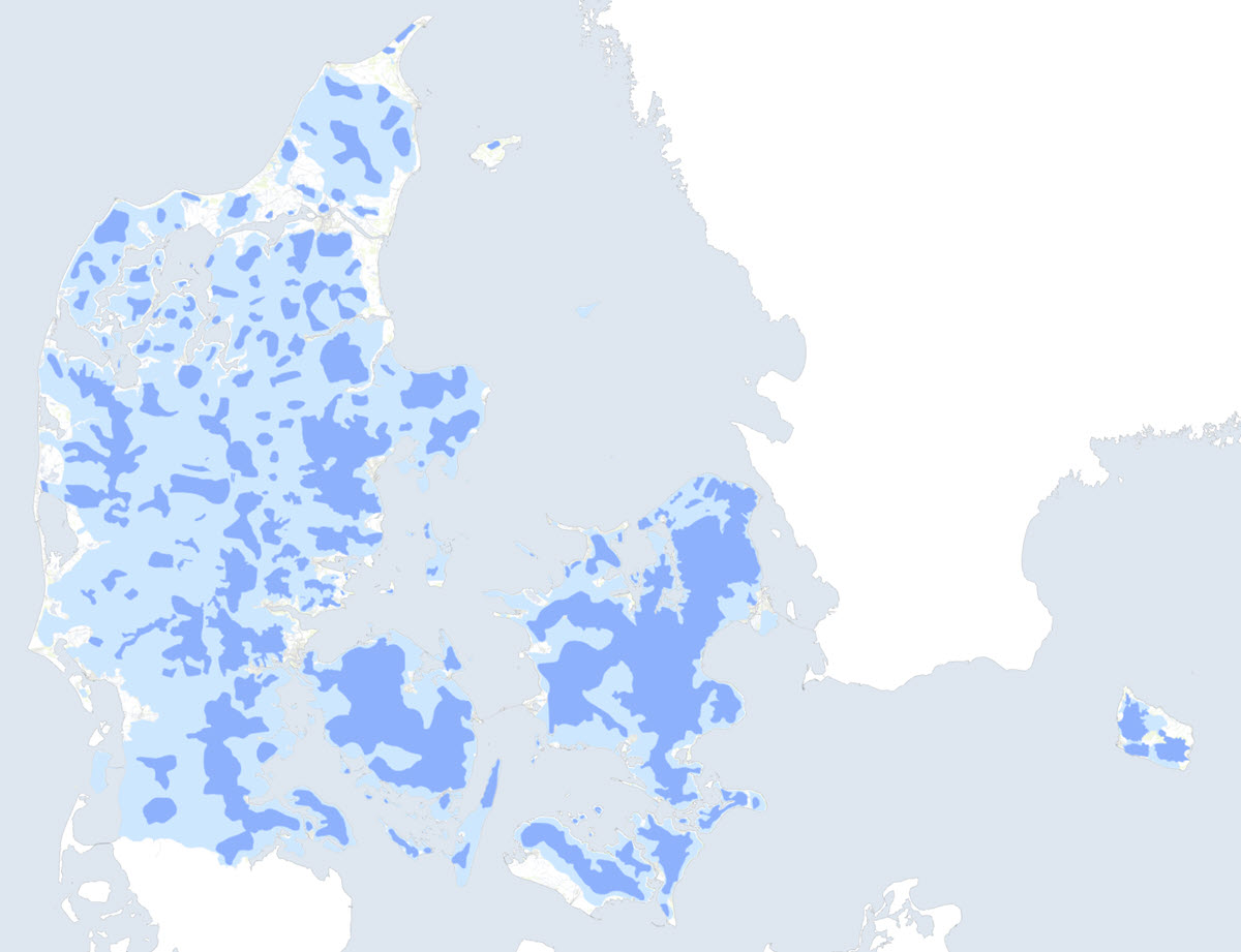
Areas of interest for drinking water in Denmark
The chorus shows drinking water areas in the categories:
· Areas with drinking water interests (OD)
· Areas of special drinking water interest (OSD)
Areas of special drinking water interest (OSD) have the highest priority for drinking water. Within these areas (as well as in extraction catchments for public waterworks), the fee-financed groundwater mapping is carried out in accordance with the Environmental Objectives Act, § 8a. It is also within these areas that action plans are drawn up according to Chapter 3 of the Water Supply Act.
Simple
- Date (Publication)
- 2023-10-10
- Identifier
- dk.geus: / drikkevandsinteresse
- Presentation form
- Digital map
- Purpose
- Display of areas with drinking water interests (OD) and areas with special drinking water interests (OSD) in Denmark.
- Status
- Completed
- Maintenance and update frequency
- As needed
- GEMET - INSPIRE themes, version 1.0
-
- Geology
- Environmental monitoring facilities
- Land use
- Protected sites
- Keywords
-
- Drikkevandsinteresse
- Drinking water
- Access constraints
- Copyright
- Use constraints
- Copyright
- Other constraints
- The map can be published by agreement with GEUS and the Danish Environmental Protection Agency.
- Other constraints
- Conditions for re-use of data https://data.geus.dk/geusmap/terms_20140620.pdf
- Spatial representation type
- Vector
- Denominator
- 100000
- Distance
- -1 m
- Metadata language
- dan
- Topic category
-
- Geoscientific information
- Environment
- Inland waters
))
- Reference system identifier
- EPSG / https://epsg.io/25832
- Geometric object type
- Complex
- Distribution format
-
-
Web Service
(
1.3.0
)
-
Web Service
(
1.3.0
)
- OnLine resource
-
Denmark's Geology Portal
(
WWW:LINK-1.0-http--link
)
GEUS' web portal for geological maps of Denmark
- OnLine resource
-
Webservice
(
OGC:WMS-1.3.0-http-get-capabilities
)
Web service for the dataset
- Hierarchy level
- Dataset
Conformance result
- Date (Publication)
- 2010-12-08
- Explanation
- This field has no significance
- Pass
- No
- Statement
- Områderne er hentet fra Miljøstyrelsen november 2022, som løbende opdateres af Miljøstyrelsen. De seneste data kan ses på Miljøstyrelsens hjemmeside (https://miljoegis.mim.dk/cbkort?&profile=grundvand). Kortet er ikke knyttet til miljoegis og afspejler ikke nødvendigvis den nyeste viden..
- File identifier
- 36ac95da-db50-447a-89b5-414842c32e2a XML
- Metadata language
- dan
- Hierarchy level
- Dataset
- Date stamp
- 2025-11-14T15:36:31
- Metadata standard name
- ISO 19115:2003 / ISO 19139:2007
Overviews
Spatial extent
Provided by
