 Geus Geonetworks metadata catalogue
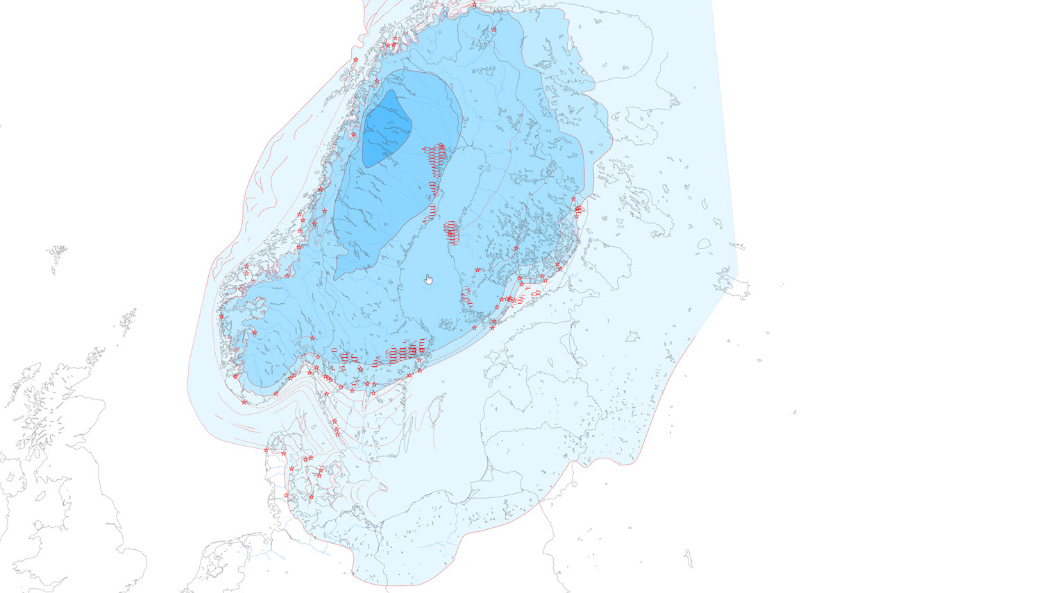
Quaternary ice margin lines in Scandinavia
Map of ice margin lines and localities in Scandinavia. The map shows the gradual melting of the Scandinavian ice sheet during the last Ice Age - the Weichsel Ice Age. The map was prepared in 1995 and consists of polygons showing the extent of the ice sheet in 5 periods, recent ice sheets, ice margin locations, De Geer moraines, ice margin lines and hypothetical ice margin lines. The map is produced for viewing at 1:1 million and is included as part of "Israndslinier i Norden" published by the Nordic Council of Ministers in TemaNord 1998:584.
Simple
- Date (Revision)
- 2011-11-30
- Identifier
- dk.geus: / Israndslinjer i Norden
- Presentation form
- Digital map
- Purpose
- The project 'Israndslinier i Norden' was a project in 1995 by the Nordic Council of Ministers. Stig Schack Petersen participated as GEUS's representative.
- Status
- Completed
Point of contact
Geological Survey of Denmark and Greenland
-
Regarding inquiries
Øster Voldgade 10
,
København
,
1350 K
,
Danmark
- Maintenance and update frequency
- As needed
- GEMET - INSPIRE themes, version 1.0
-
- Geology
- Keywords
-
- Ice margin
- Deglaciation
- Access constraints
- Copyright
- Use constraints
- Copyright
- Other constraints
- The map may be published with the consent of GEUS.
- Other constraints
- Conditions for re-use of data https://data.geus.dk/geusmap/terms_20140620.pdf
- Spatial representation type
- Vector
- Denominator
- 1000000
- Distance
- -1 m
- Metadata language
- dan
- Topic category
-
- Geoscientific information
- Climatology, meteorology, atmosphere
- Imagery base maps earth cover
N
S
E
W
))
- Reference system identifier
- EPSG / https://epsg.io/25832
- Geometric object type
- Complex
- Distribution format
-
-
Web Service
(
1.3.0
)
-
Web Service
(
1.3.0
)
Distributor
Geological Survey of Denmark and Greenland (GEUS)
-
Christian Brogaard Pedersen
Øster Voldgade 10
,
København
,
1350 K
,
Danmark
- OnLine resource
-
Denmark's Geology Portal
(
WWW:LINK-1.0-http--link
)
GEUS' web portal for geological maps of Denmark
- OnLine resource
-
Download
(
WWW:DOWNLOAD-1.0-http--download
)
Download dataset from GEUS' Dataverse
- OnLine resource
-
Webservice
(
OGC:WMS-1.3.0-http-get-capabilities
)
Web service for the dataset
- Hierarchy level
- Dataset
Conformance result
- Date (Publication)
- 2010-12-08
- Explanation
- This field has no significance
- Pass
- No
- Statement
- EITHER data processing history for GEUS Data OR reference to Data source for foreign data
- File identifier
- daa1a7fd-b1d3-482d-a557-a91e536b2ca8 XML
- Metadata language
- dan
- Hierarchy level
- Dataset
- Date stamp
- 2023-11-01T16:46:49
- Metadata standard name
- ISO 19115:2003 / ISO 19139:2007
Point of contact
Geological Survey of Denmark and Greenland
-
Metadata contact person
Øster Voldgade 10
,
København
,
1350 K
,
Danmark
Overviews
Spatial extent
N
S
E
W
Provided by

Associated resources
Not available