 Geus Geonetworks metadata catalogue
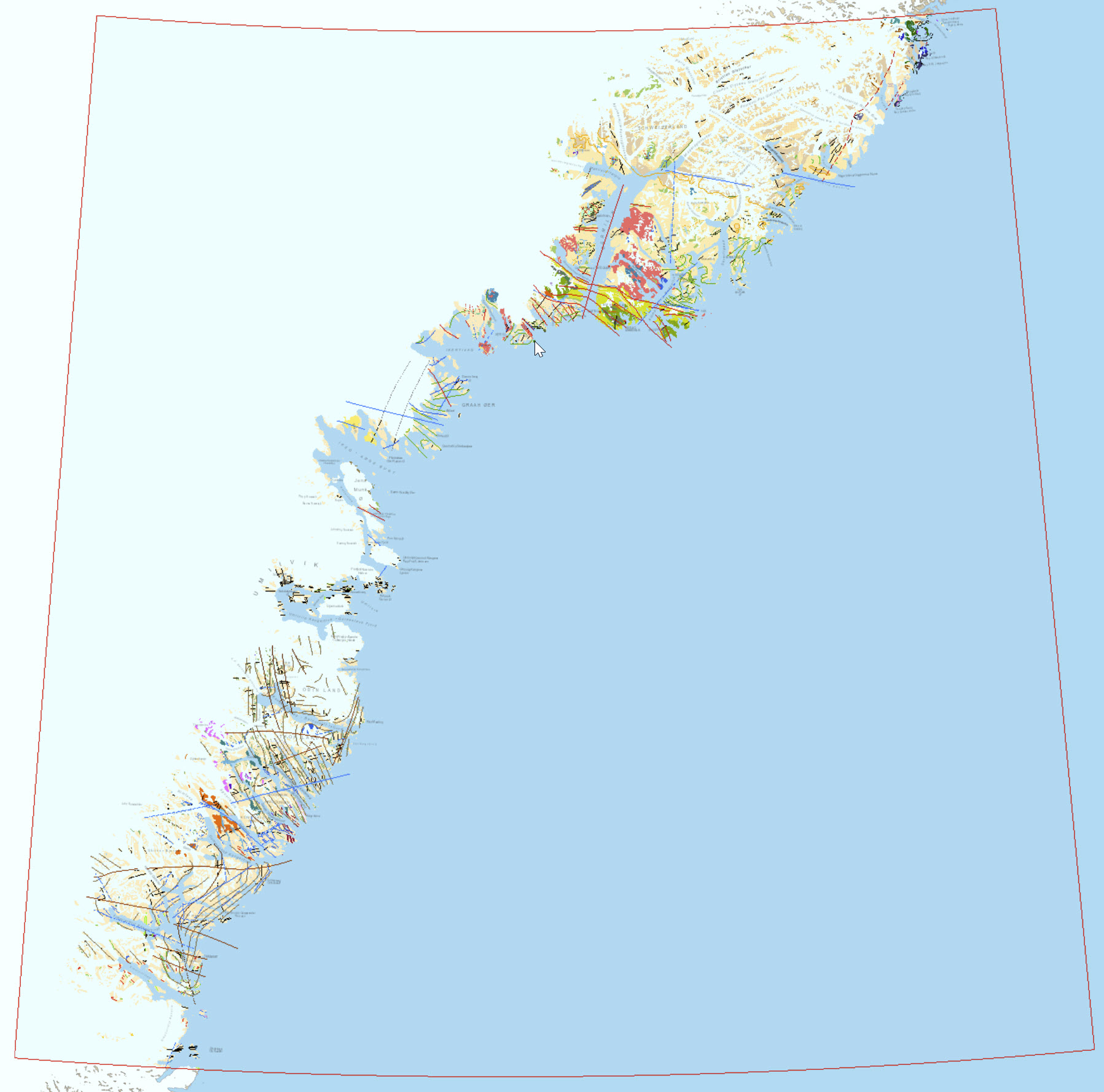
Geological map of South-East Greenland 1:500 000
The area in South-East Greenland between 62°30’N and 66°30’N was targeted for its mineralisation potential through data collection and renewed mapping during the collaborative ‘SEGMENT’ project (2009-2014) between the Geological Survey of Denmark and Greenland (GEUS) and the Bureau of Minerals and Petroleum (BMP, now Ministry of Mineral Resources, MMR). The main aims of the ‘SEGMENT’ project included:
• Compiling a regional stream sediment geochemical and till indicator mineral survey;
• Compiling a regional aeromagnetic survey of South-East Greenland;
• Conduct geological field investigations in order to characterise the main lithology
and as the basis for geological research, including petrology, structural geology,
geochemistry and geochronology;
• Evaluate economic geology and mineral potential through field investigations, using
geological parameter in order to be able to predict possible mineralisation;
• Revise the existing 1:500 000 geological map of South-East Greenland; and
• Integrated data interpretation to describe and provide a geological model for the
geological evolution of South-East Greenland and assess the mineral of potential of
the region.
The details behind the data collection and mapping efforts under the ‘SEGMENT’ project are summarized in the GEUS report by Kolb et al. (2016) which provides an overview of the geology and the lithological units within the mapping area between 62°N and 66°30’N.
Simple
- Date (Revision)
- 2022-01-01
- Identifier
- dk.geus: / Not delivered. Refer to contact persons.
- Presentation form
- Digital map
- Purpose
- Geological map
- Status
- Completed
- Maintenance and update frequency
- As needed
- GEMET - INSPIRE themes, version 1.0
-
- Geology
- Keywords
-
- Continents, countries, sea regions of the world.
-
- Greenland
- Access constraints
- Copyright
- Use constraints
- Copyright
- Other constraints
- Conditions for Re-use of data https://data.geus.dk/geusmap/terms_20140620.pdf
- Spatial representation type
- Vector
- Denominator
- 500000
- Metadata language
- English
- Topic category
-
- Geoscientific information
))
- Reference system identifier
- EPSG / https://epsg.io/32624
- Geometric object type
- Complex
- Distribution format
-
-
Web Service
(
1.0
)
-
Web Service
(
1.0
)
- OnLine resource
-
Geology and Mineral Potential of South-East Greenland
(
WWW:LINK-1.0-http--link
)
GEUS report no. 2016/38, Kolb et al.: Geology and Mineral Potential of South-East Greenland
- OnLine resource
-
Geological map of South-East Greenland 1:500 000
(
WWW:LINK-1.0-http--link
)
PDF version of 1:500 000 geological map of South-East Greenland (revised 2016; Stensgaard et al. 2016)
- Hierarchy level
- Dataset
Conformance result
- Date (Publication)
- 2010-12-08
- Explanation
- This field has no significance
- Pass
- No
- Statement
- Prior to 2009 the official geological map of the area was the 1:500 000 map compiled by Escher (1994), which was based on joint efforts by numerous involved partners over several decades, principally geologists from British Universities in the 1960s, later joined by geologists from the Greenland Geological Survey (GGU) in the late 1960s and until the early 1980s. Helicopter and fixed-wing aircraft support was first available in 1986 and 1987, where areas further inland could be mapped. The efforts by universities and GGU were accompanied by some mineral exploration by companies such as Kryolitselskabet Øresund A/S and Nordisk Mineselskab A/S. The main commodities that have received most attention includes graphite mineralisation north of Tasiilaq and nickel-PGE sulphide mineralisation in the Ammassalik Intrusive Complex close to Tasiilaq.
- File identifier
- caff5248-8a3c-42b0-9b24-a97525c11487 XML
- Metadata language
- English
- Hierarchy level
- Dataset
- Date stamp
- 2023-04-12T09:38:13
- Metadata standard name
- ISO 19115:2003 / ISO 19139:2007
Overviews
Spatial extent
Provided by
