 Geus Geonetworks metadata catalogue
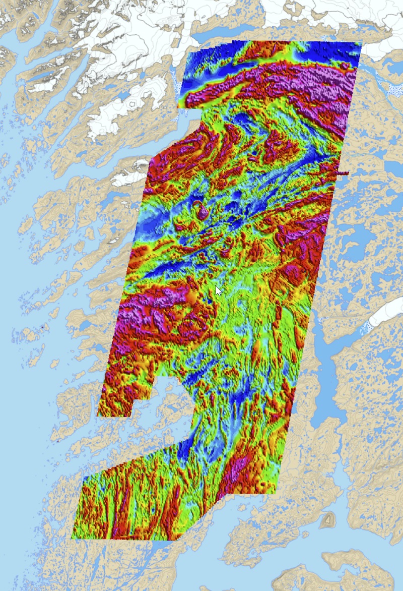
AEM 1994-1998 Surveys
The AEM Greenland 19941998 are detailed surveys with combined electromagnetic and magnetic measurements that were carried out within a collaboration between GEUS/GGU and the Greenland Government in six selected areas of expected high mineral potential in Greenland. In total, 75 000 line km covering an area of 23 000 km² were measured in the project. Line spacing was 200 400 m (inline direction) and flight altitudes were typically around 120 m. With exception of one survey the collected electromagnetic data were time-domain data (GEOTEM system).
Simple
- Date (Creation)
- 2020-02-20
- Identifier
- dk.geus: / aem_1994_1998_surveys
- Presentation form
- Digital map
- Purpose
- The project was initiated and designed to encourage mineral exploration at that time. Presented maps are based on data processed by GEUS.
- Status
- Completed
Point of contact
Geological Survey of Denmark and Greenland (GEUS)
-
Björn H. Heincke
Oster Voldgade 10
,
Copenhagen
,
1350 K
,
Denmark
- Maintenance and update frequency
- As needed
- GEMET - INSPIRE themes, version 1.0
-
- Geology
- Keywords
-
- Total magnetic intensity
- Aeromagnetic
- Continents, countries, sea regions of the world.
-
- Greenland
- Access constraints
- Copyright
- Use constraints
- Copyright
- Other constraints
- No limitations on public access
- Other constraints
- Conditions for Re-use of data https://data.geus.dk/geusmap/terms_20140620.pdf
- Spatial representation type
- Grid
- Denominator
- 200000
- Distance
- 100 m
- Metadata language
- English
- Topic category
-
- Geoscientific information
N
S
E
W
))
- Reference system identifier
- EPSG / https://epsg.io/32624
- Geometric object type
- Surface
- Distribution format
-
-
Web Service
(
1.0
)
-
Web Service
(
1.0
)
Distributor
Geological Survey of Denmark and Greenland (GEUS)
-
Christian Brogaard Pedersen
Oster Voldgade 10
,
Copenhagen
,
1350 K
,
Denmark
- OnLine resource
-
Interactive map
(
WWW:LINK-1.0-http--link
)
Greenland Portal
- OnLine resource
-
Web page
(
WWW:LINK-1.0-http--link
)
Geophysical mapping info page
- OnLine resource
-
Web Service
(
OGC:WMS-1.3.0-http-get-capabilities
)
Geophysics magnetic AEM compilation
- Hierarchy level
- Dataset
Conformance result
- Date (Publication)
- 2010-12-08
- Explanation
- This field has no significance
- Pass
- No
- Statement
- Due to the dense line spacing (200 - 400 m) and low altitudes, the magnetic datasets have generally high resolution. However, the quality of the processing is variable and some of the resulting magnetic datasets show remaining leveling artefacts in the higher order derivatives (status: Feb 2020). For these datasets re-processing is recommended. The time-domain electromagnetic were acquired with a system from the 90s, whose data quality and resolution is not comparable with the ones of modern systems. In one of the surveys (AEM96), also radiometric, VLF and frequency domain data were collected. The quality of the radiometric data is poor and options for reprocessing are lacking because the spectral raw data are not available
- File identifier
- b88bc17f-65dd-46ff-836c-29f3bd3894c6 XML
- Metadata language
- English
- Hierarchy level
- Dataset
- Date stamp
- 2023-09-08T14:09:37
- Metadata standard name
- ISO 19115:2003 / ISO 19139:2007
Point of contact
Geological Survey of Denmark and Greenland (GEUS)
-
Metadata contact person
Oster Voldgade 10
,
Copenhagen
,
1350 K
,
Denmark
Overviews
Spatial extent
N
S
E
W
Provided by

Associated resources
Not available