 Geus Geonetworks metadata catalogue
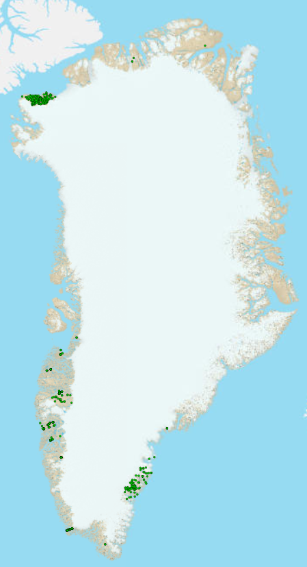
Soil sample geochemistry from Greenland
Samples of surface material, i.e. stream sediment, soil, and scree have been collected over large parts of Greenland from 1974 onwards mainly as part of mineral exploration programmes and more broadly for geochemical mapping by means of stream sediment (Steenfelt 1999, 2001). Following various sample preparation procedures, like drying and screening, making concentrates of heavy minerals from stream sediment or soil, certain fractions of the samples have been chemically analysed at diverse laboratories where a range of analytical methods were applied as they became available over the years. The present dataset contains the analytical data from soil samples as they were received from the laboratories together with administrative data, including sample location and grain-size fraction analysed.
Many samples have been analysed at more than one laboratory and by more than one method and the analytical data for each sample and grain size fraction are listed lab by lab and method by method in the same row. Five samples are used in the Geochemical Atlas of Stream sediment samples of South-West Greenland (Steenfelt, 1999). 204 samples from North Greenland have been used in the Geochemical Atlas of Stream sediment samples for North Greenland (Thrane 2011). In addition soil samples were collected in the SEGMENT project (Kolb et al. 2016)
Simple
- Date (Revision)
- 2023-11-13
- Identifier
- dk.geus: / geochemistry_soil
- Presentation form
- Digital map
- Status
- Completed
- Maintenance and update frequency
- As needed
- GEMET - INSPIRE themes, version 1.0
-
- Geology
- Mineral resources
- Keywords
-
- geochemistry
- Access constraints
- Copyright
- Use constraints
- Copyright
- Other constraints
- No limitations on public access
- Other constraints
- Conditions for Re-use of data http://pubs.geus.net/et_dokument
- Spatial representation type
- Vector
- Spatial representation type
- Grid
- Denominator
- -1
- Distance
- -1 m
- Metadata language
- English
- Topic category
-
- Geoscientific information
- Location
))
- Reference system identifier
- EPSG / https://epsg.io/32624
- Geometric object type
- Point
- Distribution format
-
-
shape file
(
0.1
)
-
shape file
(
0.1
)
- OnLine resource
-
Download
(
WWW:DOWNLOAD-1.0-http--download
)
Geochemical analyses of Soil samples from Greenland
- OnLine resource
- Interactive map ( WWW:LINK-1.0-http--link )
- OnLine resource
-
Publication
(
WWW:LINK-1.0-http--link
)
Steenfelt, A. 1999: Compilation of data sets for a geochemical Atlas. Danmarks og Grønlands Geologiske Undersøgelse Rapport 41, 33 pp
- OnLine resource
-
Report
(
DOI
)
Steenfelt, A. (2001). Calibration of stream sediment data from West and South Greenland A supplement to GEUS Report 1999/41. (Danmarks og Grønlands Geologiske Undersøgelse Rapport; Vol. 2001, No. 47). GEUS
- OnLine resource
-
Publication
(
DOI
)
Thrane, K., Steenfelt, A. & Kalvig, P. 2011: Zinc potential in North Greenland. 64 pp. Danmarks og Grønlands Geologiske Undersøgelse Rapport 2011/143
- OnLine resource
-
Publication
(
WWW:LINK-1.0-http--link
)
Kolb, J., Stensgaard, B. M., & Kokfelt, T. F. (red.) (2016). Geology and Mineral Potential of South-East Greenland. Final report from the South-East Greenland Mineral Endownment task (SEGMENT). (Danmarks og Grønlands Geologiske Undersøgelse Rapport; Bind 2016, Nr. 38). GEUS.
- Hierarchy level
- Dataset
Conformance result
- Date (Publication)
- 2010-12-08
- Explanation
- This field has no significance
- Pass
- No
- Statement
- The measured values below the lower limit of detection are set to 0. Information about sample preparation and analytical methods have been quality controlled and grain-size fractions have been added to the extract. Methods by which the geographical coordinates were obtained before 2000 were updated based on personal communcation with Agnete Steenfelt. The extract has columns for each combination of laboratory, analytical method, sample preparation, element and unit of measure. Particularly for older analytical data, information about lower limit of detection may be lacking.
- File identifier
- a5940447-d373-4814-9be5-d8cc14dad63c XML
- Metadata language
- English
- Parent identifier
- Soil sample geochemistry 37a312b1-36e2-46ad-ac72-b6b8fd967cee
- Hierarchy level
- Dataset
- Date stamp
- 2023-12-08T15:44:11
- Metadata standard name
- ISO 19115:2003 / ISO 19139:2007
Overviews
Spatial extent
Provided by
