 Geus Geonetworks metadata catalogue
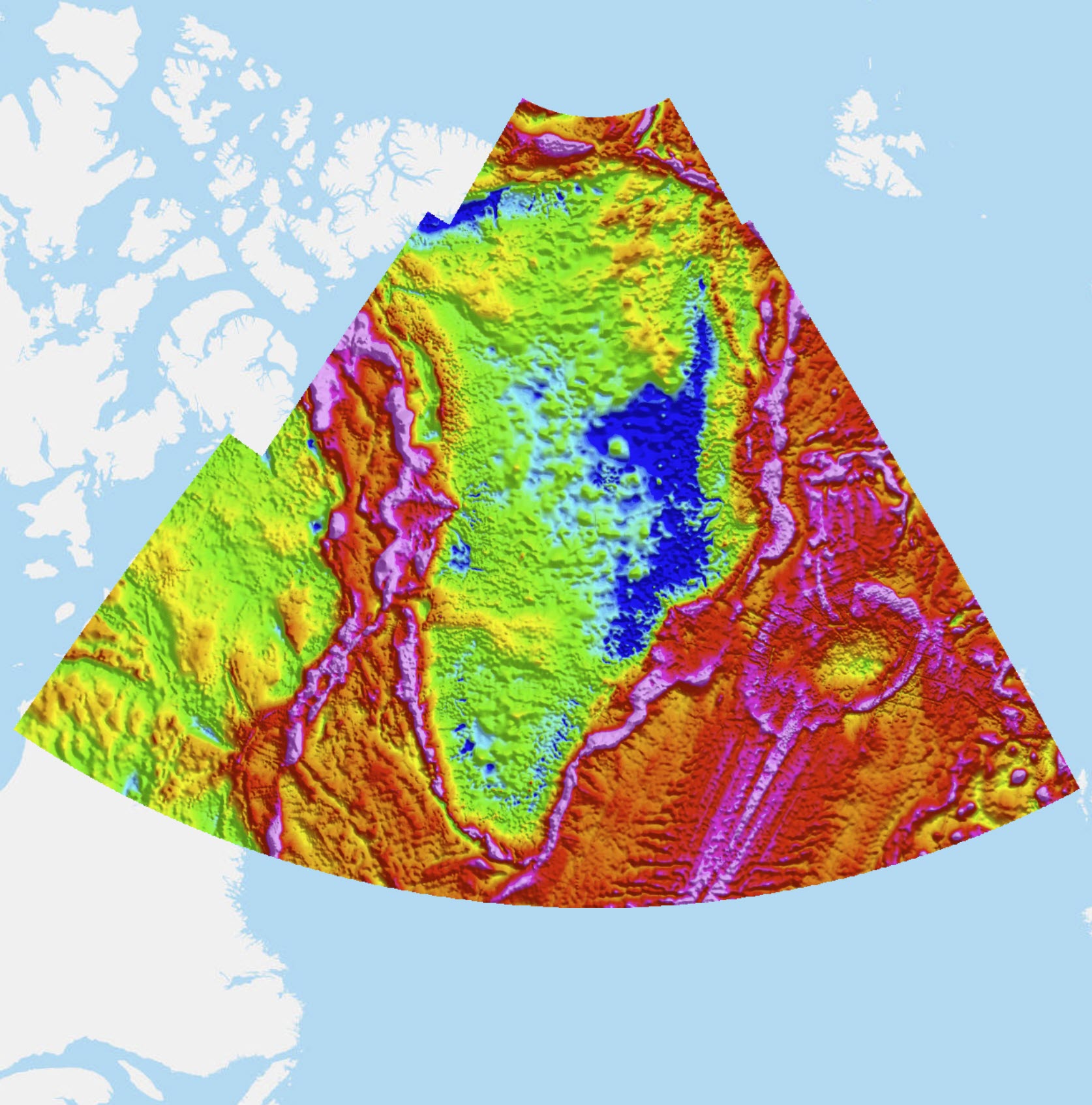
DTU gravity compilation
The gravity compilation is based on data stored in the national/Nordic gravity data base at the DTU Space. This data base contains for Greenland data surveyed by DTU Space on behalf of the geodetic survey authorities “Danish Agency for Data Supply and Efficiency” (SDFE) and its predecessor agencies “National Survey and Cadastre” (KMS) and the Geodetic Institute (GI), with some data dating back to the 1950’s. Older data have been rectified into modern gravity datums (absolute gravimetry and IGSN71). The national data contains both surface, airborne and marine data, mainly in the coastal ice-free regions and offshore (Forsberg et al, 2001, Kenyon et al, 2008). Airborne, marine and land data from a number of external data sources are also included in the data base after a QC process, including high-level airborne data from the GAP91/92 campaigns (Brozena et al, 1993) and recent data from NASA OIB (MacGregor et al., 2021) and OMG projects (Fenty et al., 2016). Marine data in the Baffin Bay and Davis Strait and land data from the Geodetic Survey Division, Canada (Veronneau 2010, pers.comm.), and a number of other marine and land data from a large set of contributors have also been included in the compilation, including marine data from Alfred Wegener Institute (Germany), land and marine data from Orkustofnun (Iceland), and a number of released commercial data sources. In areas void of gravity data, satellite-derived altimetry data have been used as fill-in (DTU 15, Andersen et al. 2017).
The compiled grids have been based on public domain and some proprietary data sources, and has been computed for the area 58-85°N, 78-7°W on a 0.02°x 0.05° grid, using rigorous downward continuation of airborne data to the terrain surface, with terrain corrections from a detailed digital terrain and ice sheet surface model, and long-wavelength satellite gravity data from GRACE and GOCE satellites (Forsberg and Olesen, 2010). The data are available as a free-air (Faye) anomaly grid as well as a derived terrain-corrected Bouguer anomaly grid (land and ice sheet areas only), computed in GRS80 with density 2.67 g/cm3. The ice sheet Bouguer anomaly data are derived using the ice sheet thickness model of Bamber et al., 2013. The free-air gravity grid (v1) have also have been used as the primary background data also for the latest geoid models of Greenland (GGEOID16).
Simple
- Date (Revision)
- 2022-01-01
- Identifier
- dk.geus: / grl_geophysical_dtu_magnetic_anomaly
- Presentation form
- Digital map
- Status
- Completed
- Maintenance and update frequency
- As needed
- GEMET - INSPIRE themes, version 1.0
-
- Geology
- Keywords
-
- Gravity
- Free air
- Geophysics
- Bouguer anomaly
- Continents, countries, sea regions of the world.
-
- Greenland
- Access constraints
- Copyright
- Use constraints
- Copyright
- Other constraints
- Only gridded data available, due to restrictions on some commercial and governmental data. Note that the Bouguer grid is land only, free-air at sea.
- Other constraints
- Conditions for Re-use of data https://data.geus.dk/geusmap/terms_20140620.pdf
- Spatial representation type
- Vector
- Spatial representation type
- Grid
- Denominator
- -1
- Distance
- -1 m
- Metadata language
- English
- Topic category
-
- Geoscientific information
))
- Reference system identifier
- EPSG / http://www.opengis.net/def/crs/EPSG/0/3044
- Geometric object type
- Surface
- Distribution format
-
-
Web Service
(
1.0
)
-
Web Service
(
1.0
)
- OnLine resource
- Interactive map ( WWW:LINK-1.0-http--link )
- OnLine resource
-
Bouguer anomaly
(
OGC:WMS-1.3.0-http-get-map
)
Gravity (DTU) - Bouguer (land) + Free-air (sea) anomaly - this wms link only works in geonetworks viewer when projection is set to utm24
- OnLine resource
-
Global gravity field from recent satellites (DTU15) — Arctic improvements
(
DOI
)
Andersen, O.B., P. Knudsen, S. Kenyon, J.K. Factor and S. Holmes: Global gravity field from recent satellites (DTU15) — Arctic improvements. First Break, Volume 35, Issue 12, Dec 2017
- OnLine resource
-
A new bed elevation dataset for Greenland
(
DOI
)
Bamber, J. L., Griggs, J. A., Hurkmans, R. T. W. L., Dowdeswell, J. A., Gogineni, S. P., Howat, I., Mouginot, J., Paden, J., Palmer, S., Rignot, E., and Steinhage, D.: A new bed elevation dataset for Greenland, The Cryosphere, 7, 499–510
- OnLine resource
-
New technology allows remote areas to be probed
(
DOI
)
Brozena, J., Chalona, M., Forsberg, R. and G. Mader: New Technology allows remote areas to be probed – the Greenland Aerogeophysics Project. In: EOS – Transactions American Geoph. Union, vo. 74, no. 2, p. 18, January 1993
- OnLine resource
-
Oceans Melting Greenland: Early Results from NASA’s Ocean-Ice Mission in Greenland
(
DOI
)
Fenty, I., Willis, J. K., Khazendar, A., Dinardo, S., Forsberg, R., Fukumori, I., Holland, D., Jakobsson, M., Moller, D., Morison, J., Munchow, A., Rignot, E., Schodlok, M., Thompson, A. F., Tinto, K., Rutherford, M. & Trenholm, N.Oceans Melting Greenland: Early Results from NASA's Ocean-Ice Mission in Greenland In: Oceanography. 29, 4, p. 72-83, 2016.
- OnLine resource
-
Airborne gravity survey of the North Greenland continental shelf
(
WWW:LINK-1.0-http--link
)
Forsberg, R., A. V. Olesen, K. Keller: Airborne gravity survey of the North Greenland continental shelf. In: Sideris, M. G. (ed): Gravity, Geoid and Geodynamics 2000, International Association of Geodesy Symposia, vol. 123, pp. 235-240, Springer Verlag, 2001.
- OnLine resource
-
Airborne Gravity Field Determination
(
WWW:LINK-1.0-http--link
)
Forsberg, R and A. V. Olesen: Airborne gravity field determination. In: G. Xu (ed): Sciences of Geodesy – I, Advances and Future Directions, pp. 83-104, Springer Verlag, ISBN 978-3-642-11741-1, 2010.
- OnLine resource
-
New Gravity Field for the Arctic
(
WWW:LINK-1.0-http--link
)
Kenyon, S., R. Forsberg, and B. Coakley: New Gravity Field for the Arctic, Eos Trans. AGU, 89(32), doi:10.1029/2008EO320002, 2008.
- OnLine resource
-
Publication
(
DOI
)
MacGregor, J.A., L. N. Boisvert, B. Medley, A. A. Petty, J. P. Harbeck, R. E. Bell, J. B. Blair, E. Blanchard-Wrigglesworth and more co-authors: The Scientific Legacy of NASA’s Operation IceBridge. Reviews of Geophysics, vol. 059, issue 2, June 2021, doi.org/10.1029/2020RG000712
- Hierarchy level
- Dataset
Conformance result
- Date (Publication)
- 2010-12-08
- Explanation
- This field has no significance
- Pass
- No
- Statement
- The grid data accuracy depends strongly on the location. In well-surveyed ice-free areas data accuracy will be at the few mGal level. Larger errors are occurring close to the ice sheet margins and along deep fjords, where unknown fjord depths, lack of ice sheet radar thickness data, and missing marine gravity data over fjords, can give errors well above 50 mGal locally.
- File identifier
- 6d9f5c54-527e-4dee-ab49-4016d4810fc8 XML
- Metadata language
- English
- Hierarchy level
- Dataset
- Date stamp
- 2023-08-08T11:53:44
- Metadata standard name
- ISO 19115:2003 / ISO 19139:2007
Overviews
Spatial extent
Provided by
