 Geus Geonetworks metadata catalogue
Regional Radiometry 1975-1982 Surveys
The regional-scale gamma spectrometry data are associated with two collaboration projects involving the Geological Survey of Greenland (GGU) and the Danish Atomic Energy Commission’s Research Establishment. The projects' objectives were to outline areas with an elevated uranium potential in two regions of Greenland: The airborne radiometric surveys in southern and central West Greenland in 1975/76 and the SYDURAN project in South Greenland in 1979-1982. To acquire the data, four-channel gamma ray spectrometers were mounted upon an aircraft (1975/76 surveys) and a helicopter (SYDURAN project). The vehicles flew along shoreline and valley contour lines at low average terrain clearances of 100 and 50 m respectively. The data were recorded without GPS systems, and so positioning was estimated when known landmarks were passed. This means that the dataset is sparse and inhomogeneous, and the spatial accuracy remains low. The gamma-spectrometer had been calibrated at a pad facility at Risø, which enabled the conversion of recorded counts per second into simulated concentrations of radioactive components in the surface of the overflown terrain.
Large parts of the data (surveys from 1975/76) were originally stored on magnetic tapes and data were transferred to datafiles in 2003 to make them digital accessible. Most data were retrieved and are now available as ASCII files.
Simple
- Date (Revision)
- 2022-01-01
- Identifier
- dk.geus: / radiometry
- Presentation form
- Digital map
- Status
- Completed
- Maintenance and update frequency
- As needed
- GEMET - INSPIRE themes, version 1.0
-
- Geology
- Keywords
-
- GGU
- Radiometry
- Continents, countries, sea regions of the world.
-
- Greenland
- Access constraints
- Copyright
- Use constraints
- Copyright
- Other constraints
- No limitations on public access
- Other constraints
- Data is not confidential
- Spatial representation type
- Grid
- Spatial representation type
- Grid
- Denominator
- 200000
- Distance
- 100 m
- Metadata language
- English
- Topic category
-
- Geoscientific information
))
- Begin date
- 1975-01-01
- End date
- 1983-01-01
- Reference system identifier
- EPSG / https://epsg.io/32624
- Geometric object type
- Complex
- Distribution format
-
-
Web Service
(
1.0
)
-
Web Service
(
1.0
)
- OnLine resource
-
Interactive map
(
WWW:LINK-1.0-http--link
)
Interactive airborne radiometery maps on the Greenland Portal
- OnLine resource
-
Web Service
(
OGC:WMS
)
grl_geophysic_radiometry
- OnLine resource
-
Publication
(
WWW:LINK-1.0-http--link
)
Radiometry 75-76 (West Greenland)
- OnLine resource
-
Publication
(
WWW:LINK-1.0-http--link
)
South Greenland Regional Uranium Exploration Project
- OnLine resource
-
Web Service
(
OGC:WMS-1.3.0-http-get-capabilities
)
TC_all_utm24n
- Hierarchy level
- Dataset
Conformance result
- Date (Publication)
- 2010-12-08
- Explanation
- This field has no significance
- Pass
- No
- Statement
-
Due to the sparse data coverage with surveying along contour lines and the lack of GPS positioning, both the spatial resolution and the spatial accuracy is low. In addition, some of the data (1975/76 surveys) were originally stored on magnetic tapes, which were partly under bad physical conditions.
The company DRTS Ltd, St Pauls Cray, Kent, England, a private company specialized in the recovery of data from old tapes, was contracted from GEUS to transfer the data from the tapes and most - but not all - of the data were recovered. Details about the data recovery process and data quality evaluation of the 1975/76 are given in the GEUS report 2003-37 “Digital airborne radiometric data from the 1975 and 1976” and we recommend to contact Thorkild Maack Rasmussen (now Luleå University, formerly GEUS), who was involved in this process, for any further information about this process.
Only counts for four windows were collected (probably total count, K, eU, eTh) and spectral data are missing. This very much limits the options of reprocessing and more advanced processing techniques for noise removal and radon reduction in the uranium window are not possible.
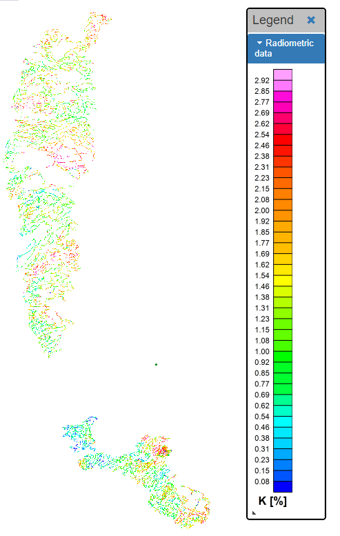
The gamma-spectrometer had been calibrated at a pad facility at Risø, which enabled the conversion of recorded counts per second in the four channels to simulated concentrations of radioactive components in the surface of the overflown terrain and K is given in % and eU and eTh in ppm.
In summary, the datasets are not comparable with nowadays acquired radiometric airborne data, neither in their data quality nor in the uniformity and density of the data coverage. This means the main value of these data lie in the regional extent such that large areas of West Greenland and South Greenland can be qualitatively evaluated in terms of the natural radioactive isotopes.
- File identifier
- 368ed153-74e2-4eec-9970-99e221654ae3 XML
- Metadata language
- English
- Hierarchy level
- Dataset
- Date stamp
- 2023-06-23T14:22:50
- Metadata standard name
- ISO 19115:2003 / ISO 19139:2007
Overviews
Spatial extent
Provided by
