Geus Geonetworks metadata catalogue
Geological Screening for Offshore Wind
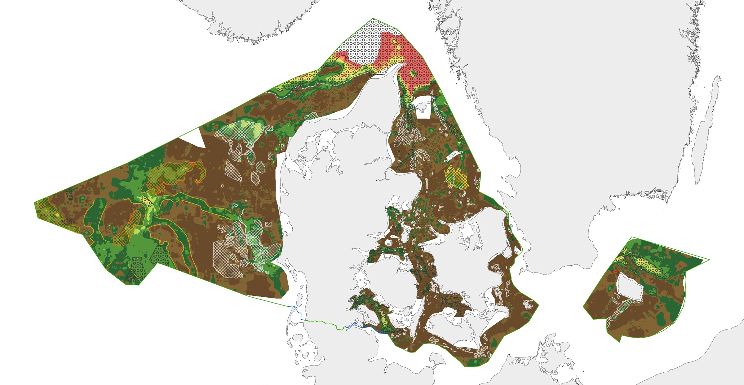
This repository contains maps of the thickness of late glacial and Holocene deposits in the Danish sea area, prepared as a basis for planning offshore wind. These are unconsolidated sediments that have not been overrun by the ice sheets of the ice ages, and therefore may have low geotechnical strength parameters.
This is a large-scale and very general mapping, and no detailed interpretation of the distribution of sand and clay/mud/silt, respectively, has been made. In relation to the foundations of offshore wind turbines, sandy deposits will typically not pose a challenge, while soft deposits of clay, mud and silt in large thicknesses are assumed to pose foundation challenges.
In addition to separate maps of the thickness of late glacial and Holocene deposits, a map of the total thickness of these two units has also been prepared, which thus constitutes a map of the total thickness of potentially soft sediments. Finally, the thickness of potentially soft sediments is used to divide the Danish sea area into categories in relation to the probability of larger thicknesses of soft sediments that could give rise to foundation challenges.
Other maps are the thickness of potentially soft glacial lake sediments in the North Sea, the depth to the Pre-Quaternary surface in the waters around Bornholm, as well as the depth to the base of the Holocene deposits and the depth to the base of the late glacial deposits/top of the glacial deposits in the Danish sea area.
As a supplement to the maps, a number of themes show where the late glacial and Holocene deposits are primarily expected to consist of sandy sediments. In addition, a number of themes show the Danish exclusive economic zone (EEZ), the location of conceptual geological models that can be seen in the overall report, all interpreted seismic lines, areas with near-surface gas in the sediments, interpreted distribution of the Palaeo-Elbe Valley in the North Sea, distribution of the Weichsel ice and ice-affected sediments in the North Sea, buried valleys (Prins & Andresen 2019; van der Vegt et al. 2012; Ottesen et al. 2020; Kirkham et al. 2024; Sandersen & Jørgensen 2016), structural elements (Al Hseinat & Hübscher 2017; Jensen et al. 2002), ice margin lines (Lange 1984; Kjær et al. 2003; Pedersen 2005; Phillips et al. 2018, 2022; Kirkham et al. 2024; Szuman et al. 2024; Pedersen & Boldreel 2017).
The data basis for the work has primarily been new and existing near-surface seismic data and vibrocore drilling. The mapping was carried out for the Danish Energy Agency by GEUS, and is intended to support the development of offshore wind. The results, together with a sensitivity mapping of natural and environmental parameters, initiated by the Danish Energy Agency, are to be included in an overall assessment of suitable areas for offshore wind in Denmark.
The documentation includes appendices: Better geological data for developing offshore wind - Overall geological mapping of the Danish sea area for the Danish Energy Agency. Appendix report. Geological Survey of Denmark and Greenland Report 2025/29.
Vangkilde-Pedersen, T., Christensen, N., Nørgaard-Pedersen, N., Allaart, L., Bennike, O., Leth, J.O., Winther, L.H., Sandersen, P.B.E., Prins, L.T., Singhroha, S. & Pérez, L.F. 2025. Better geological data for developing offshore wind. Overall geological mapping of the Danish sea area for the Danish Energy Agency. Geological Survey of Denmark and Greenland Report 2025/29.
Prins, L.T. & Andresen, K.J. 2019: Buried late Quaternary channel systems in the Danish North Sea – genesis and geological evolution. Quaternary Science Reviews 223, 105943. https://doi.org/10.1016/j.quascirev.2019.105943
van der Vegt, P., Janszen, A. & Moscariello, A. 2012: Tunnel valleys: Current knowledge and future perspectives. In: Huuse, M., Redfern, J., Le Heron, D.P., Dixon, R., Moscariello, A. & Craig, J. (eds): Glaciogenic reservoirs and hydrocarbon systems. Geological Society, Special Publications, London 368, 75–97. https://doi.org/10.1144/sp368.13
Ottesen, D., Stewart, M., Brönner, M. & Batchelor, C.L. 2020: Tunnel valleys of the central and northern North Sea (56◦N to 62◦N): distribution and characteristics. Marine Geology 425, 106199. https://doi.org/10.1016/j.margeo.2020.106199
Kirkham, J.D., Hogan, K.A., Larter, R.D., Self, E., Games, K., Huuse, M., Stewart, M.A., Ottesen, D., Le Heron, D.P., Lawrence, A., Kane, I., Arnold, N.S. & Dowdeswell, J.A. 2024: The infill of tunnel valleys in the central North Sea: Implications for sedimentary processes, geohazards, and ice-sheet dynamics. Marine Geology 467, 107185.
https://doi.org/10.1016/j.margeo.2023.107185
Sandersen, P.B.E. & Jørgensen, F. 2016: Kortlægning af begravede dale i Danmark. Opdatering 2015. GEUS Særudgave, december 2016, bind 1 og 2.
Al Hseinat, M. & Hubscher, C. 2017: Late Cretaceous to recent tectonic evolution of the north German Basin and the transition zone to the Baltic Shield/Southwest Baltic Sea. Tectonophysics 708, 28–55. https://doi.org/10.1016/j.tecto.2017.04.021
Jensen, J.B. & Bennike, O. 2022: Geological Screening of Kriegers Flak North and South. Geological seabed screening in relation to possible location of windfarm areas. GEUS Rapport 2022/2. https://doi.org/10.22008/gpub/34637
Lange, D., 1984: Geologische Untersuchungen an spätglazialen und holozänen Sedimenten der Lübecker und Mecklenburger Bucht. Unveröffentlichte Dissertation (B), Institut für Meereskunde Warnemünde, 166 S.
Kjær, K.H., Houmark-Nielsen, M., Richardt, N. 2003: Ice-flow patterns and dispersal of erratics at the southwestern margin of the last Scandinavian ice sheet: signature of palaeo-ice streams. Boreas 32: 130–148. https://doi.org/10.1111/j.1502-3885.2003.tb01434.x
Pedersen, S.A.S. 2005: Structural analysis of the Rubjerg Knude Glaciotectonic Complex, Vendsyssel, northern Denmark. Geological Survey of Denmark and Greenland Bulletin 8, 192 pp. https://doi.org/10.34194/geusb.v8.5253
Phillips, E., Cotterill, C., Johnson, K., Crombie, K., James, L., Carr, S. & Ruiter, A. 2018: Large-scale glacitectonic deformation in response to active ice sheet retreat across Dogger Bank (southern central North Sea) during the Last Glacial Maximum. Quaternary Science Reviews 179, 24-47. https://doi.org/10.1016/j.quascirev.2017.11.001
Phillips, E., Johnson, K., Ellen, R., Plenderleith, G., Dove, D., Carter, G., Dakin, N. & Cotterill, C. 2022: Glacitectonic evidence of ice sheet interaction and retreat across the western part of Dogger Bank (North Sea) during the Last Glaciation. Proceedings of the Geologists' Association 133, 87-111. https://doi.org/10.1016/j.pgeola.2021.11.005
Szuman, I., Kalita, J. Z., Diemont, C. R., Livingstone, S. J., Clark, C. D., and Margold, M. 2024: Reconstructing dynamics of the Baltic Ice Stream Complex during deglaciation of the Last Scandinavian Ice Sheet, The Cryosphere, 18, 2407–2428. https://doi.org/10.5194/tc-18-2407-2024.
Pedersen, S.A.S. & Boldreel, L.O. 2017: Glaciotectonic deformations in the Jammerbugt and glaciodynamic development in the eastern North Sea. Journal of Quaternary Science 32, 183–195. https://doi.org/10.1002/jqs.2887
Simple
- Date (Publication)
- 2025-09-19
- Identifier
- dk.geus: / Screening for Havvind
- Presentation form
- Digital map
- Purpose
-
GEUS has carried out a geological screening of the entire Danish sea area for the Danish Energy Agency with a view to establishing a better geological data basis for offshore wind development. The purpose of the project is to achieve greater certainty that a given area, in future designations of offshore wind areas, is geologically suitable for offshore wind. The results from the project, together with a sensitivity mapping of natural and environmental parameters, initiated by the Danish Energy Agency, will be included in an overall assessment of suitable areas for offshore wind in Denmark.
Through an overall geological mapping of the entire Danish sea area, a comprehensive understanding of the near-surface geological conditions under the seabed has been established. The results can be used by decision-makers to assess the suitability of individual areas for the installation of offshore wind turbines, both in relation to the thickness of soft sediments and the degree of geological complexity.
- Status
- Completed
- Maintenance and update frequency
- As needed
- GEMET - INSPIRE themes, version 1.0
-
- Geology
- Screening
- Havvind
- GEUS
- Sediments
- Seabed
- Keywords
-
- Access constraints
- Copyright
- Use constraints
- Copyright
- Other constraints
- No limitations on public access
- Other constraints
- Conditions for re-use of data https://data.geus.dk/geusmap/terms_20140620.pdf
- Spatial representation type
- Vector
- Denominator
- 100000
- Distance
- 100 m
- Metadata language
- dan
- Topic category
-
- Geoscientific information
))
- Reference system identifier
- EPSG / https://epsg.io/25832
- Geometric object type
- Complex
- Distribution format
-
-
Web Service
(
1.3.0
)
-
Web Service
(
1.3.0
)
- OnLine resource
-
Web Portal
(
WWW:LINK-1.0-http--samples
)
Portal for Geological Screening for Offshore Wind
- OnLine resource
-
OGC:WMS
(
OGC:WMS-1.3.0-http-get-map
)
GeologiskScreeningHavvind
- OnLine resource
-
Better geological data for offshore wind development - Overall geological mapping of the Danish sea area for the Danish Energy Agency
(
DOI
)
Geological Survey of Denmark and Greenland Report 2025/29
- Hierarchy level
- Dataset
Conformance result
- Date (Publication)
- 2010-12-08
- Explanation
- This field has no significance
- Pass
- No
- Statement
- EITHER data processing history for GEUS Data OR reference to Data source for foreign data
- File identifier
- 26b57e52-3c6d-4c19-9fce-6b5f98f4909e XML
- Metadata language
- dan
- Hierarchy level
- Dataset
- Date stamp
- 2025-09-30T14:29:58
- Metadata standard name
- ISO 19115:2003 / ISO 19139:2007
Overviews
Spatial extent
Provided by