 Geus Geonetworks metadata catalogue
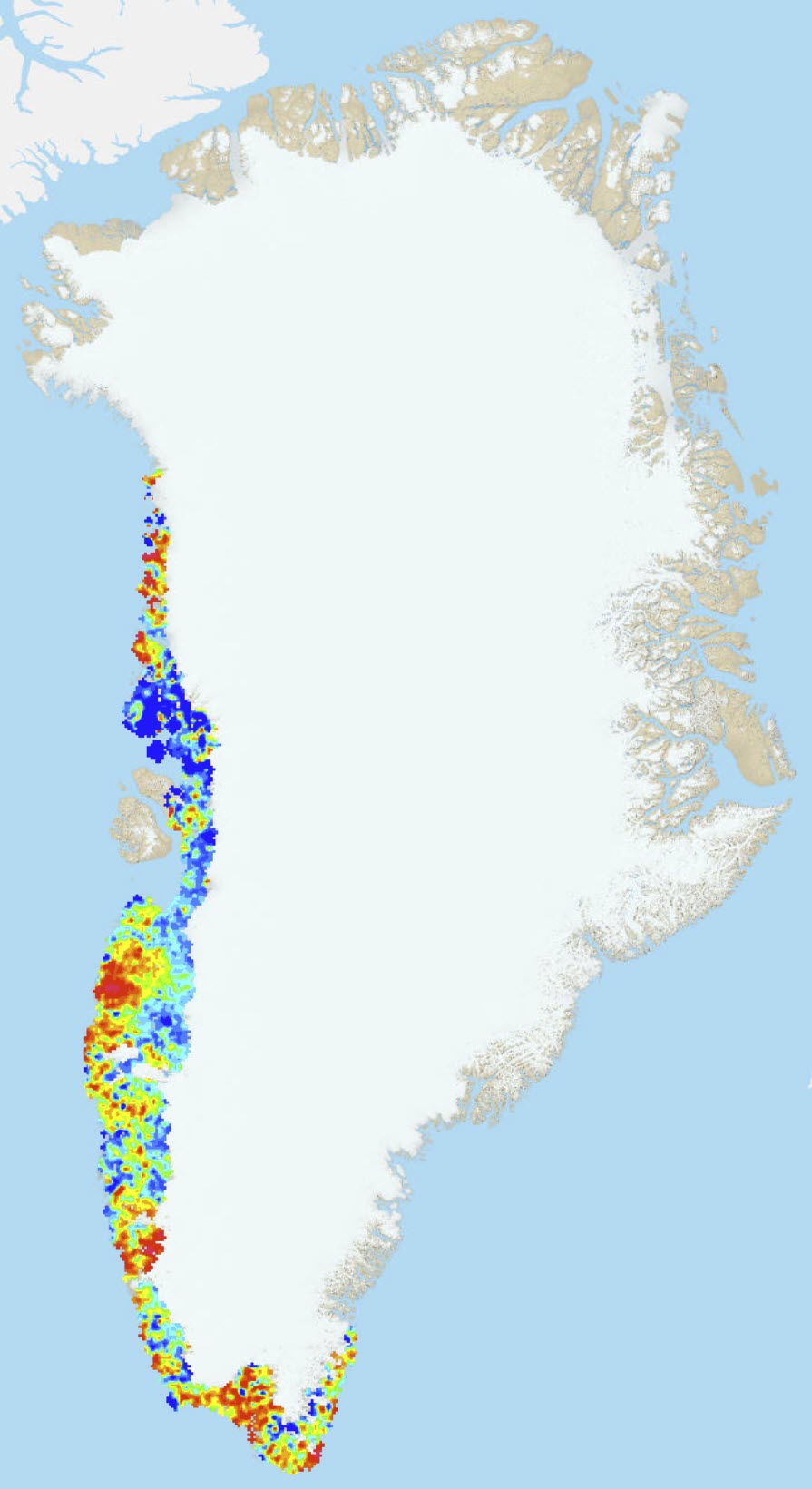
Element distribution maps of stream sediments samples from the geochemical atlas of West and South Greenland
Simple
- Date (Revision)
- 2022-01-01
- Identifier
- dk.geus: / element_maps_2001r46
- Presentation form
- Digital map
- Purpose
-
Stream sediment chemistry reflects chemical variations in rock complexes, and many element distribution patterns can be related to known lithological features. Although the rock exposure rate is generally very high in Greenland, there are inland areas in West Greenland where overburden and vegetation create problems for geological mapping. The geochemical maps helps to outline rock boundaries in such a surface environment. Also where high-grade metamorphism has obscured original textures and boundaries between lithological units, the geochemical maps may contribute valuable information. This is the case in central West Greenland where high-grade Archaean and Palaeoproterozoic gneiss complexes cannot be distinguished in the field. However, the younger gneiss has a strong geochemical signature, which is reflected in the maps of Ba and Sr. Thus an approximate outline of the younger gneiss can be drawn, based on the geochemical data. Several other cases are known from West and South Greenland, where stream sediment geochemical patterns have drawn the attention to rock complexes that had not previously been recognised.
The geochemistry of a rock unit, and its trace element signature, in particular, is an important factor in determining its origin. Many trace elements are hosted in scarce, fine-grained minerals in the rocks, e.g. apatite, zircon and monazite. These minerals are resistant to weathering with the effect that their abundance is upgraded in the stream sediments relative to their abundance in the source rocks. Again, because the stream sediment data cover regions with little or no geochemical data on rocks, the stream sediment chemical maps may assist in identifying rock complexes of a certain origin.
- Status
- Completed
- Maintenance and update frequency
- As needed
- GEMET - INSPIRE themes, version 1.0
-
- Geology
- Mineral resources
- Keywords
-
- Access constraints
- Copyright
- Use constraints
- Copyright
- Other constraints
- No limitations on public access
- Other constraints
- Conditions for Re-use of data http://pubs.geus.net/et_dokument
- Spatial representation type
- Vector
- Spatial representation type
- Grid
- Denominator
- -1
- Distance
- 5000 m
- Metadata language
- English
- Topic category
-
- Geoscientific information
))
- Reference system identifier
- EPSG / https://epsg.io/32624
- Geometric object type
- Surface
- Distribution format
-
-
geotiff files
(
0.1
)
-
geotiff files
(
0.1
)
- OnLine resource
-
Publication
(
WWW:LINK-1.0-http--link
)
A. Steenfelt 2001 Geochemical atlas of Greenland - West and South Greenland. [2 versions: Printed maps included or 1 CD-Rom included] Danmarks og Grønlands Geologiske Undersøgelse Rapport 2001/46.
- OnLine resource
-
WMS
(
OGC:WMS-1.3.0-http-get-capabilities
)
ElementMaps2001R46
- OnLine resource
- Interactive map ( WWW:LINK-1.0-http--link )
- Hierarchy level
- Dataset
Conformance result
- Date (Publication)
- 2010-12-08
- Explanation
- This field has no significance
- Pass
- No
- Statement
- Data are based on https://data.geus.dk/geonetwork/srv/eng/catalog.search#/metadata/8abf8aef-e244-4f70-9c48-a455cf4c32ae
- File identifier
- 05ba12b3-f40b-4832-9765-16d8ebb745c2 XML
- Metadata language
- English
- Hierarchy level
- Dataset
- Date stamp
- 2023-05-10T11:28:01
- Metadata standard name
- ISO 19115:2003 / ISO 19139:2007
Overviews
Spatial extent
Provided by
