 Geus Geonetworks metadata catalogue
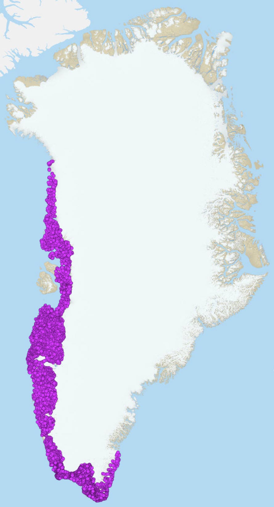
Geochemical Atlas of Stream sediment samples South-West Greenland
This view presents data from stream sediment geochemical mapping of West and South Greenland (Steenfelt, 2001a). Stream sediment samples were collected from 1979 to 1998 with as even coverage as possible from low-order streams and with a sampling density between 1 sample per 5 km2 and 1 sample per 50 km2, mostly around 1 sample per 30 km2. With few exceptions, the 0.1 mm grain size fractions of 500-g samples were analysed for major and trace elements by two or three methods. After careful quality control and elimination of bias between analytical values determined by different methods or at different times (calibration), the most reliable analytical data were selected as the final consistent dataset, containing data from 7122 samples analysed for up to 43 elements (see Steenfelt 1999, 2001b for details on data selection and calibration).
Major element oxides and volatiles are determined by X-Ray Fluorescence Spectrometry (XRF) and loss on ignition, respectively. Loss on ignition mostly reflects the amount of organic material in stream sediment samples. As the aim is to show the regional variation in the chemistry of the minerogenic component
of the stream sediment, volatiles are not included in the major element composition which is recalculated as volatile-free oxides. Instead, volatiles are listed in a separate column for documentation. Locally, high loss on ignition may be caused by high contents of carbonate in the stream sediment of streams draining rare occurrences of marble or carbonatites. For detailed or more accurate studies, the CO2 concentrations of the stream sediment samples should be measured, or the amount of carbonate minerals estimated by microscopy.
Trace element data are from methods determining total concentrations (XRF, Instrumental Neutron Activation, Delayed Neutron Counting). The quality of the trace element data varies (see Steenfelt 1999, 2001b)
In the present dataset, all values below lower detection limit are indicated by the digit 0.
Sample location
Before 1993, sample sites were originally marked on topographic maps at the scale 1:100,000 and their positions were later digitised and later again corrected, when a new topographic reference was introduced around year 2000. From 1993 onwards, GPS was used to determine sample positions.
Simple
- Date (Revision)
- 2023-11-13
- Identifier
- dk:geus: / geochemical_atlas_sw_greenland
- Presentation form
- Digital map
- Status
- Completed
- Maintenance and update frequency
- As needed
- GEMET - INSPIRE themes, version 1.0
-
- Geology
- Mineral resources
- Keywords
-
- Calibrated dataset
- Continents, countries, sea regions of the world.
-
- Greenland
- Access constraints
- Copyright
- Use constraints
- Copyright
- Other constraints
- Public access / The dataset can be used freely when acknowledged
- Other constraints
- Conditions for Re-use of data http://pubs.geus.net/et_dokument
- Spatial representation type
- Vector
- Spatial representation type
- Grid
- Denominator
- 1
- Distance
- 1 m
- Metadata language
- English
- Topic category
-
- Geoscientific information
- Location
))
- Reference system identifier
- EPSG / https://epsg.io/32624
- Geometric object type
- Point
- Distribution format
-
-
Web Service
(
1.0
)
-
Web Service
(
1.0
)
- OnLine resource
-
Download
(
WWW:DOWNLOAD-1.0-http--download
)
Geochemical Atlas of Stream sediment samples from South and West Greenland for download
- OnLine resource
- Interactive map ( WWW:LINK-1.0-http--link )
- OnLine resource
-
geochemistry_greenland_ss_sw
(
OGC:WMS-1.3.0-http-get-map
)
Geochemical Atlas of Stream sediment samples from South and West Greenland
- OnLine resource
-
WFS
(
OGC:WFS-1.0.0-http-get-capabilities
)
South West Greenland stream sediments
- OnLine resource
-
Publication
(
WWW:LINK-1.0-http--link
)
Agnete Steenfelt (1999) Compilation of data sets for a geochemical atlas of West and South Greenland based on stream sediment Danmarks og Grønlands Geologiske Undersøgelse Rapport 41
- OnLine resource
-
Publication
(
WWW:LINK-1.0-http--link
)
Steenfelt, A., 2001. Calibration of stream sediment data for West and South Greenland. A supplement to GEUSReport 1999/41
- OnLine resource
-
Publication
(
WWW:LINK-1.0-http--link
)
Steenfelt, A., 2001a. Geochemical atlas of Greenland – West and South Greenland. Danmarks og Grønlands Geologiske Undersøgelse Rapport 2001/46, 96 pp.
- Hierarchy level
- Dataset
Conformance result
- Date (Publication)
- 2010-12-08
- Explanation
- This field has no significance
- Pass
- No
- Statement
- Non provided
- File identifier
- 019cf744-b02c-4c12-91cc-3ffd5f9c2925 XML
- Metadata language
- English
- Parent identifier
- Geochemical Atlas samples South-West Greenland 8abf8aef-e244-4f70-9c48-a455cf4c32ae
- Date stamp
- 2024-01-05T15:03:49
- Metadata standard name
- ISO 19115:2003 / ISO 19139:2007
Overviews
Spatial extent
Provided by
