Guide to webGIS
-
 Blue folders are layer groups – click and open folder to expose the layers included.
-
 Green icons are separate layers – click and the layer will appear on the map.
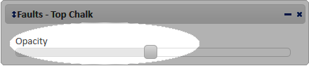
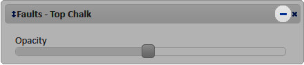
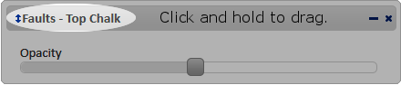
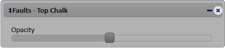
- A layer can be more or less transparent by moving the “Opacity” slide.
- The “Opacity” slide can be hidden by click on the blue dash.
- The order of layers can be changed by click and drag the layer up or down.
- Close a layer by click on the blue cross.
- Attributes are shown by click on the feature at the map. If more than one layer are open at the location all layers attributes will be shown.
Explanations to attribute data
Please note
That not all attributes are available for all features, due to data availability and confidentiality.
Storage formations, aquifers, units and traps
| Attribute abbreviation | Attribute full name | Units and explanations |
| NAME | Name | |
| COUNTRY | Country | |
| AGE | Age | |
| LITHOLOGY | Lithology | Predominant lithology |
| DEP_TOP | Depth top | Meter (m) |
| THICK | Thickness | Meter (m) |
| VOLUME | Volume | Cubic kilo meter (km3) |
| NET_GROSS | Net/gross | Fraction between 0 and 1 |
| POR | Porosity | Fraction between 0 and 1 or % |
| PERMEA | Permeability | Millidarcies (mD) |
| INJECT | Injectivity | Darcy-meter (Dm) |
| RES_TYPE | Connectivity/reservoir type | Open, half-open or closed |
| CO2_DENS | CO2 density at reservoir conditions | Ton/m3 |
| THEO_CAP | Theoretical storage capacity | Mega ton (Mt) |
| STO_EFF | Efficiency factor | Fraction between 0 and 1 |
| EFF_CAP | Effective storage capacity | Mega ton (Mt) |
| MODEL_CAP | Modelled storage capacity | Mega ton (Mt) |
Hydrocarbon fields
| Attribute abbreviation | Attribute full name | Units and explanations |
| NAME | Name | |
| COUNTRY | Country | |
| AGE | Age | |
| LITHOLOGY | Lithology | Predominant lithology |
| CO2_DENS | CO2 density at reservoir conditions | ton/m3 |
| DISCOV_Y | Discovery year | |
| CONTENT | Content | Oil, gas or mixture |
| STATUS | Status | |
| OPERATOR | Operator | |
| STOR_CAP | Storage capacity | Mega ton (Mt) |
Caprock (seal)
| Attribute abbreviation | Attribute full name | Units and explanations |
| NAME | Name | |
| COUNTRY | Country | |
| AGE | Age | |
| LITHOLOGY | Lithology | Predominant lithology |
| DEP_TOP | Depth top (average) | Meter (m) |
| DEP_BAS | Depth base (average) | Meter (m) |
| THICK | Thickness (average) | Meter (m) |
Emission point sources
| Attribute abbreviation | Attribute full name | Units and explanations |
| Facility | ||
| Sector | Industry sector | |
| Country | ||
| LAT | Latitude | |
| LONG | Longitude | |
| TOTAL_CO2 | Total CO2 emission in 2011 | Mega ton (Mt) |
| FOSSIL_CO2 | Amount of fossil CO2 emission | Mega ton (Mt) |
| BIO_CO2 | Amount of bio CO2 emission | Mega ton (Mt) |