Geology and stratigraphy
Denmark
Geological framework
The geology of Denmark is characterised by a thick cover of sedimentary rocks of Late Palaeozoic – Cenozoic age. In the Danish Basin the sedimentary succession is up to 10 km thick (Fig. 1). The basin is bounded to the north and north east by the Fennoscandian Border Zone (Sorgenfrie-Tornquist zone and Skagerrak-Kattegat Platform) and to northwest–southeast by the basement high, the Ringkøbing-Fyn High. The sedimentary cover on this structural high is relatively thin (1–2 km). The North German Basin is situated south of the basement high with sediment thickness comparable to the Danish Basin.
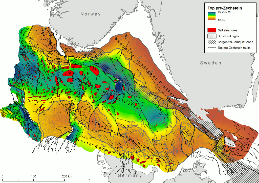
Figure 1. Map showing major structural elements and depth to top Pre-Zechstein in Denmark. Modified from Vejbæk & Britze (1984).
The sediments are affected by mainly northwest–southeast striking normal faults. In the Norwegian-Danish and North German Basin post depositional flow of Permian salt formed large domal structures, which strongly influenced later deposition. Locally the overlying sedimentary succession is deeply truncated over the top of rising salt domes and minor faults often accompany the salt structures.
Formations with saline aquifers
The most prospective formations for CO2 storage in Denmark are (Figure 2):
- Bunter Sandstone and Skagerrak Formations (Triassic)
- Gassum Formation (Upper Triassic–Lower Jurassic)
- Haldager Sand Formation (Middle Jurassic)
- Frederikshavn Formation (Upper Jurassic–Lower Cretaceous)
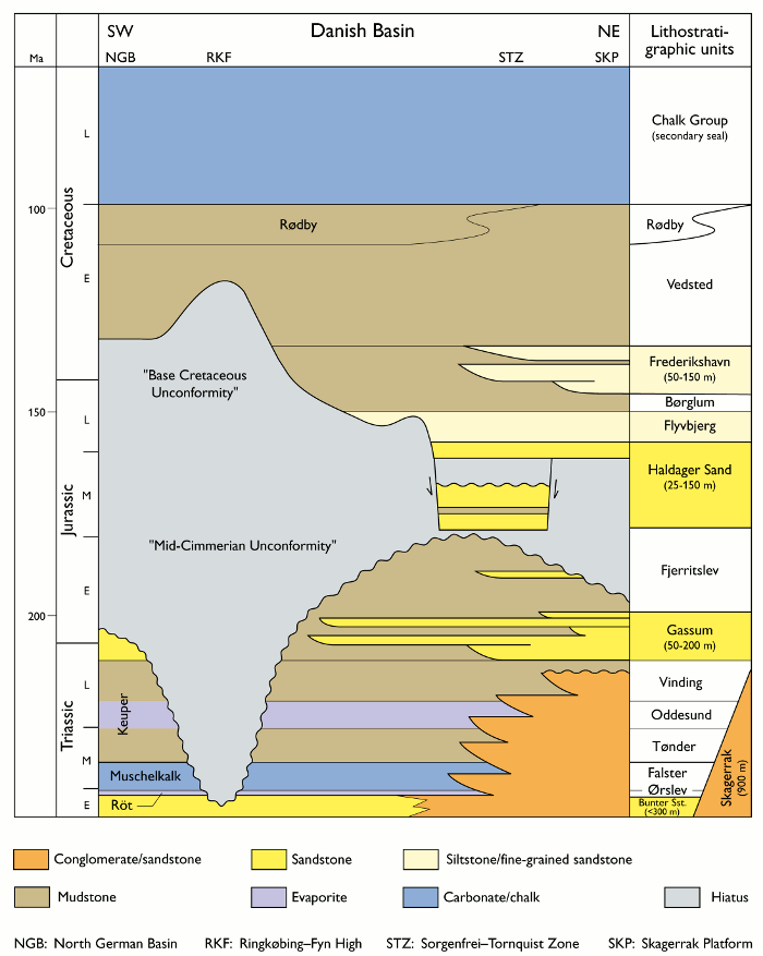
Figure 2. Simplified stratigraphy and lithostratigraphy of the sedimentary succession in the Danish part of the Norwegian-Danish Basin. (Based on Bertelsen 1980, Michelsen & Clausen 2002; Michelsen et al. 2003).
Bunter Sandstone/Skagerrak Formations (Triassic)
The Bunter Sandstone/Skagerrak Formations are present throughout the Danish area. Sandstones of the Bunter Sandstone Formation are dominant in the southern, western and central part of the Danish area and are gradually replaced by the Skagerrak Formation towards the north eastern basin margin.
The Lower Triassic sandstone dominated succession (Bunter Sandstone and Skagerrak) forms a widespread unit with thickness around 300 m although it may reach 900 m in the central part of the Danish Basin. The succession is thin and locally absent across the Ringkøbing-Fyn High. It is anticipated that no strong primary hydraulic barriers exist within the sheet sandstone (Sørensen et al. 1998).
Reservoir properties are poorly known and often based on estimates from petrophysic logs (Michelsen et al. 1981). The porosity estimates range between 0–24% (maximum 38%) whereas the permeability is generally low (10–100 mD) due to the relatively deep burial depth causing diagenetic changes and cement formation. Unexpected good reservoir properties have been found in the time equivalent Ljunghusen Formation in the Copenhagen area.
Gassum Formation (Upper Triassic–Lower Jurassic)
The formation is present in the Norwegian-Danish Basin. It shows a remarkable continuity with thickness between 100 and 150 m throughout most of Denmark, reaching a maximum thickness of 300 m in the Sorgenfrei-Tornquist Zone.
The Gassum Formation consists of fine- to medium-grained, locally coarse-grained sandstones interbedded with heteroliths, claystones and locally thin coal beds (Michelsen et al. 2003; Nielsen 2003). In general the reservoir properties are excellent with porosity 18–27% (maximum 36%) and permeability up to 2000 mD.
The Gassum Formation forms the reservoir in the Stenlille natural gas storage and has been studied in great detail (Nielsen et al. 1989; Hamberg & Nielsen 2000; Nielsen 2003). The studies illustrate the facies complexity and the lateral variability present within the reservoir units. Each of these units may act as discrete reservoir units and is characterised by a set of porosity/permeability parameters. Based on palaeogeographic reconstructions it is anticipated that the sand content will decrease towards the northwest.
Haldager Sand Formation (Middle Jurassic)
The formation is present in the central and northern part of the Norwegian-Danish Basin, in the Sorgenfrei-Tornquist Zone and on the Skagerrak-Kattegat Platform reaching a maximum thickness of 150 m. The porosity varies between 12 and 33% (maximum 42%) whereas permeability have only been estimated in two wells having 600 and 2000 mD respectively.
The Haldager Sand Formation consists of thick beds of fine- to coarse-grained, locally pebbly sandstones intercalated with thin siltstone, claystone and coal beds. Deposition was locally affected by movements of underlying salt structures.
Frederikshavn Formation (Upper Jurassic–Lower Cretaceous)
The formation is present in the northern part of the Norwegian-Danish Basin and reaches a maximum thickness of more than 230 m in the Sorgenfrei-Tornquist fault zone. Local faults and salt tectonics mainly control thickness variations.
The formation consists of siltstones and fine-grained sandstones forming 2–3 coarsening-upwards units separated by claystones (Michelsen et al. 2003). The most coarse-grained parts of the formation are present in the northeast towards the Skagerrak-Kattegat Platform whereas the formation interfingers with the fine-grained Børglum Formation towards the west (Michelsen et al. 2003).
Formations with caprock properties (seal)
The aquifer storage of CO2 is dependent not only on the properties of the reservoir but also on the integrity of the sealing formation. Geological formations in Denmark with sealing properties are lacustrine and marine mud rocks, evaporites and carbonates. The most important sealing rock type in the Danish area is marine mudstone, which is present at several stratigraphic levels. Leakage may take place through the cap rock due to slow capillary migration, through micro-fractures or along faults. Detailed site surveys will be needed in order to test the integrity of the seal at future storage sites.
The Ørslev, Falster, Oddesund Formations were defined by Bertelsen (1980). A revised stratigraphy for the Triassic was suggested by Michelsen & Clausen (2002). They suggest adopting the stratigraphy used for a similar stratigraphic unit in the North German Basin for the Danish area south of the Ringkøbing-Fyn High.
Ørslev/Röt Formation (Lower Triassic)
The formation is transitional to the coarse-grained deposits of the Skagerrak Formation forming the northern edge of the depositional system. The fine-grained Ørslev Formation reaches 100–400 m in thickness south of the Ringkøbing-Fyn High.
Muschelkalk /Falster Formation (Middle Triassic)
The formation is described as a unit characterised by intercalated limestones, claystones and halites. Fine-grained sandstones are locally present in the upper part of the formation. The formation reaches 100–200 m in thickness and forms a secondary seal for the Bunter Sandstone Formation in the Rødby and Tønder structures.
Keuper /Oddesund Formation (Upper Triassic)
The formation is described as a unit characterised by calcareous, anhydritic claystones and siltstones intercalated with thin beds of dolomitic limestone. In the central part of the Danish Basin two prominent units of halite is present dividing the formation into three informal members. The formation varies in thickness due to local up lift of the underlying Zechstein salt and reaches a maximum thickness of 1500 m.
Fjerritslev Formation (Lower Jurassic)
The formation is characterised by a relatively uniform succession of marine, slightly calcareous claystones, with varying content of silt and siltstone laminae. Siltstones and fine-grained sandstones are locally present being most common in the north-eastern, marginal areas of the Norwegian-Danish Basin (Michelsen 1975, 1978, Michelsen et al. 2003). The formation is present over most of the Danish Basin with a thickness of up to 1000 m although this varies significantly due to mid-Jurassic erosion.
Flyvbjerg and Børglum Formations
The Flyvbjerg Formation consists primarily of siltstones and fine-grained sandstones with poor reservoir quality and is neither regarded as a reservoir formation nor as a seal. However, it directly overlies the Haldager Sand Formation and thus may act as a transitional formation into the sealing claystones of the overlying Børglum Formation.
The Upper Jurassic Børglum Formation consists of a uniform succession of slightly calcareous claystones (Michelsen et al. 2003). The Børglum Formation is present in most of the Danish Basin and reaches a maximum thickness of 300 m towards the Fjerritslev Fault. It rapidly thins towards the northeast, south and southwest.
Vedsted and Rødby Formations (Lower Cretaceous)
Marine mudstones of the Vedsted and Rødby Formations form the primary sealing formation for the Frederikshavn Formation.
Chalk Group (Upper Cretaceous – Lower Palaeocene)
In most of the Danish area a several kilometres thick succession of carbonate rocks forms a possible secondary seal. The sealing effect is dependent on chemical reactions between dissolved CO2 and the carbonate rock.
References
Bertelsen, F. 1980: Lithostratigraphy and depositional history of the danish Triassic. Geological Survey of Denmark. Series B 4, 59 pp.
Hamberg, L. & Nielsen, L.H. 2000: Shingled, sharp-based shoreface sandstones and the importance of stepwise forced regression in a shallow basin, Upper Triassic Gassum Formation, Denmark. In: Hunt, D. & Gawthorpe, T.L. (eds): Sedimentary responses to forced regressions. Geological Society Special Publication (London) 172, 69–89.
Michelsen, O. 1975: Lower Jurassic biostratigraphy and ostracods of the Danish Embayment. Danmarks Geologiske Undersøgelse II. Række 104, 287 pp.
Michelsen, O. 1978: Stratigraphy and distribution of Jurassic deposits of the Norwegian–Danish Basin. Danmarks Geologiske Undersøgelse Serie B 2, 28 pp.
Michelsen, O (ed.). 1981: Kortlægning af potentielle geotermiske reservoirer i Danmark. Danmarks Geologiske Undersøgelse Serie B 5, 28 pp.
Michelsen, O. & Clausen, O.R. 2002: Detailed stratigraphic subdivision and regional correlation of the southern Danish Triassic succession. Marine and Petroleum Geology 19, 563–587.
Michelsen, O., Nielsen, L.H., Johannessen, P.N., Andsbjerg, J. & Surlyk, F. 2003: Jurassic lithostratigraphy and stratigraphic development onshore and offshore Denmark. In: Ineson, J.R. & Surlyk, F. (Eds.) The Jurassic of Denmark and Greenland. Geology of Denmark Survey Bulletin 38.
Nielsen, L.H. 2003: Late Triassic – Jurassic development of the Danish Basin and the Fennoscandian Border Zone, southern Scandinavia. In: Ineson, J.R. & Surlyk, F. (Eds.) The Jurassic of Denmark and Greenland. Geology of Denmark Survey Bulletin 38.
Nielsen, L.H., Larsen, F. & Frandsen, N. 1989: Upper Triassic–Lower Jurassic tidal deposits of the Gassum Formation on Sjælland, Denmark. Geological Survey of Denmark. DGU Series A 23, 30 pp.
Sørensen, K., Nielsen, L.H., Mathiesen, A. & Springer, N. 1998: Geotermi i Danmark: Geologi og ressourcer. Danmarks og Grønlands Geologiske Undersøgelse Rapport 1998/123, 24 pp.
Vejbæk, O.V. & Britze, P. 1984: Top præ-Zechstein. Danmarks Geologiske Undersøgelse Map series 45.
Finland
Finland is a part of the Baltic shield (also called the Fennoscandian shield) consisting of Pre-Cambrian crystalline rocks leaving no option for CO2 storage in sedimentary aquifers (Teir et al. 2010). Finland might have a minor potential for utilising ultra-mafic rocks for mineral carbonisation (Aatos et al. 2006).
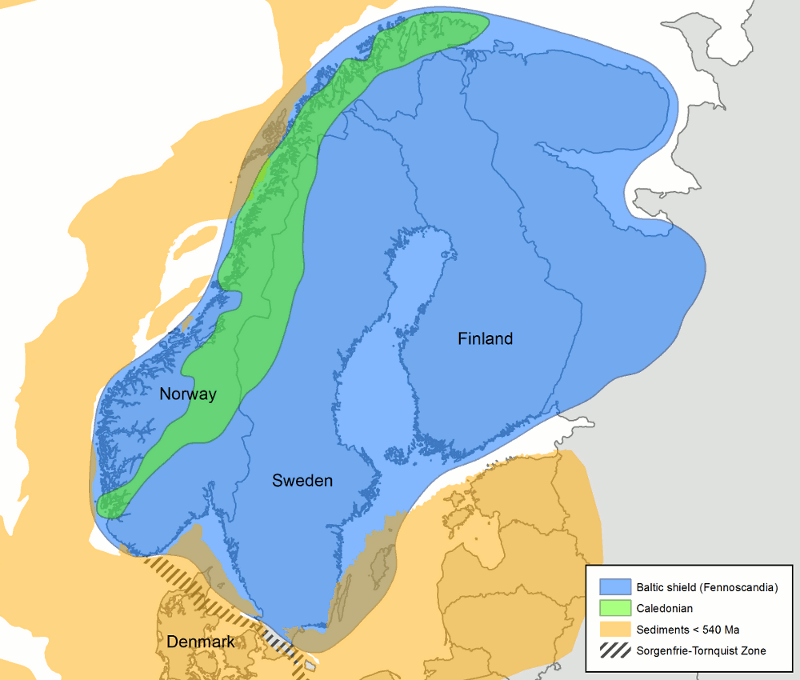
Fig. 1. Generalised geological overview of the Baltic shield.
References
Teir S, Hetland H, Lindeberg E, Torvanger A, Buhr K, Koljonen T, Gode J et al.. Potential for carbon capture and storage (CCS) in the Nordic region. VTT Research Notes 2556; 2010.
Aatos S, Sorjonen-Ward P, Kontinen A, Kuivasaari T. Serpentiinin ja serpentiniitin hyötykäyttönäkymiä (Outlooks for utilisation of serpentine and serpentinite). Report No. M10.1/2006/3. Geological Survey of Finland (GSF); 2006.
Iceland
Geological and tectonic settings
Iceland sits astride the North Atlantic plate boundary where the North American and the Eurasian plate are separated and is one of only two places on Earth where an oceanic spreading centre rises above sea level. Iceland is the largest landmass above the mid-oceanic ridges, and the largest area of sub-aerially exposed mid-oceanic ridge on Earth (Höskuldsson et al., 2007).
The Iceland basalt plateau rises more than 3000 m above sea level and covers about 350,000 km2 including the terrestrial 103,000 km2 of Iceland (Thordarson and Höskuldsson, 2008). Iceland is mostly (~90%) made of young 0-20 M yr. basaltic rocks of igneous origin and sediments thereof (Hjartarson and Sæmundsson, 2014)(Fig. 1). The width of the relatively flat shelf around Iceland is from less than 15 km from the south coast to more than 120 km, with the average width being about 80 km (Kristjánsson 1979).
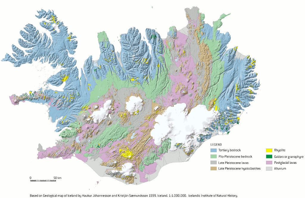
Figure 1. Geological map of Iceland, 1 :1 000 000. (Modified from Jóhannesson and Sæmundsson, 1999)
The plate boundary in, and close to Iceland is composed of several rift segments and transform zones, forming an overlapping spreading centre with propagating rifts both at the southern and northern parts of the island (Fig. 2) (Einarsson, 2008; Sigmundsson, 2006), with spreading rate of about 18-20 mm/yr (Arnadottir et al., 2008). The plate boundary is affected by a hot spot presumed to be fed by a deep mantle plume (Bjarnason, 2008).
In SW-Iceland, at the tip of the Reykjanes peninsula, the offshore Reykjanes Ridge (RR) meets the on-land Reykjanes Volcanic Belt (RVB) which extends to form the West Volcanic Zone (WVZ). The Eastern Volcanic Zone (EVZ) extends from the eastern end of the South Iceland Seismic Zone (SISZ) and joins the Northern Volcanic Zone (NVZ) and the Mid-Iceland Belt (MIB) in a triple junction. In N-Iceland the Northern Volcanic Zone is linked to the offshore Kolbeinsey Ridge (KR) by the NW-trending Tjörnes Fracture Zone (TFZ) (e.g. Einarsson, 1976; Einarsson, 1991).

Figure 2. The main outline of the geology in Iceland, outlining the distribution of the major geological subdivisions, including the main fault structures and volcanic zones and belts. RR, Reykjanes Ridge; RVB, Reykjanes Volcanic Belt; WVZ, West Volcanic Zone; MIB, Mid-Iceland Belt; SISZ, South Iceland Seismic Zone; EVZ, East Volcanic Zone; NVZ, North Volcanic Zone; TFZ, Tjörnes Fracture Zone (From Thordarson, 2012).
Iceland is one of the most active and productive sub-areal volcanic regions on Earth with magma output rates of more than five km3 per century (Thordarson and Höskuldsson, 2008). Magma production within the active rift zone is influenced by the combination of the hot spot and rifting and exceeds the extension generated by the plate boundaries.
The volcanic zones are 20-50 km wide belts located within the active rift zone with geological formations consisting of basaltic lavas, hyaloclastic (glassy) formations and associated sediments younger than 0.8 M yr covering about one third of Iceland (Hjartarson and Sæmundsson, 2014).
Mineral storage of CO2 in Iceland
The geological setting of Iceland and lack of large sedimentary basins make storage of CO2 as a separate buoyant phase impractical. Instead, an alternative method is being tested in Iceland, where the CO2 is dissolved in water during injection into basaltic rocks (e.g. Gislason and Oelkers, 2014).
Basaltic rocks are rich in divalent cations (e.g. Ca2+, Mg2+ and Fe2+). The CO2-charged water accelerates metal release and the formation of solid carbonate minerals such as Calcite (CaCO3), Magnesite (MgCO3) and Siderite (FeCO3) and solid solutions thereof, for long term storage of CO2 (e.g. Gislason and Oelkers, 2014).
Studies on the permeability and porosity of Icelandic bedrock show that porosity and permeability generally decrease with progressive alteration, gradual burial and increasing rock age since most of the pore space in the older rocks is filled with secondary minerals (Frolova et al., 2004; Neuhoff et al., 2008). Thus, the youngest basaltic formations, found in the active rift zone and covering about one third of Iceland, are the most feasible for carbon storage onshore in Iceland (Fig. 3).
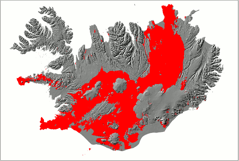
Figure
3.
Theoretical area feasible for CO2 mineral storage in Iceland: Young and porous
basaltic rocks (>0.8 M yr) within the active rift zone covering about one
third of Iceland (from
Snæbjörnsdóttir et al., 2014).
References
Arnadottir, T., Geirsson, H., Jiang, W., 2008. Crustal deformation in Iceland: Plate spreading and earthquake deformation. Jökull, 58.
Bjarnason, I., 2008. An Iceland Hotspot Saga. Jökull, 58: 3-16.
Einarsson, P., 1976. Relative location of earthquakes in the Tjörnes Fracture Zone. Geodynamica Acta Islandica, V: 45–60.
Einarsson, P., 1991. Earthquakes and present day tectonism in Iceland. Tectonophysics, 189: 261–279.
Einarsson, P., 2008. Plate boundaries, rifts and transforms in Iceland. Jökull 58: 35–58.
Frolova, J. et al., 2004. Porosity and permeability of hyaloclastites tuffs, Iceland, International Geothermal Workshop IGW2004 “Heat and light from the heart of the earth”, Petropavlovsk-Kamchatsky,, pp. 10.
Gislason, S.R., Oelkers, E.H., 2014. Carbon Storage in Basalt. Science, 344: 373-374.
Hjartarson, Á., Sæmundsson, K., 2014. Geological Map of Iceland. Bedrock. 1:600 000. Iceland GeoSurvey, Reykjavik.
Höskuldsson, Á., Hey, R., Kjartansson, E., Guðmundsson, G.B., 2007. The Reykjanes Ridge between 63°10’N and Iceland. Journal of Geodynamics, 43: 73-86.
Jóhannesson, H., Sæmundsson, K., 1999. Geological map of Iceland 1:1.000.000. Iceland Institute of Natural History, Iceland.
Kristjánsson , l., 1979. The shelf around Iceland. Jökull, 29: 3-6.
Neuhoff, P.S., Fridriksson, T., Armannsson, H., 2008. Porosity evolution and mineral paragenesis during low-grade metamorphism of basaltic lavas at Teigarhorn, Eastern Iceland. American Journal of Science, 299: 467-501.
Sigmundsson, F., 2006. Iceland Geodynamics. Crustal Deformation and Divergent Plate Tectonics. Springer-Verlag, Berlin, Germany.
Snæbjörnsdóttir, S.Ó. et al., 2014. CO2 storage potential of basaltic rocks in Iceland and the oceanic ridges. Energy Procedia, 63: 4585-4600.
Thordarson, T., 2012. Outline of Geology of Iceland, AGU Chapman Conference on Volcanism and the Atmosphere. AGU, Selfoss, Iceland.
Thordarson, T., Höskuldsson, Á., 2008. Postglacial volcanism in Iceland. Jökull, 58: 197-228.
Norway
Geological framework
The Norwegian continental shelf is divided in three different sub-provinces, the North Sea, the Norwegian Atlantic Coast, and the Barents Shelf. The creation of their sedimentary basins is connected with the break-up of the Pangea mega-continent. The North Sea and the Barents Sea are both in an intra-cratonic setting, while the Norwegian Atlantic Coast is a passive margin containing a series of continental margin basins (Ziegler et al. 1986)(Figure 1). As the break-up of Pangea started at the end of the Palaeozoic, they have all a thick cover of sediments from Late Palaeozoic to Cenozoic age.
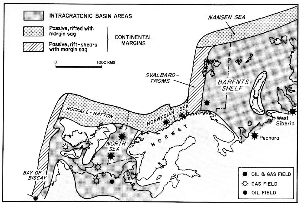
Fig. 1. Basins and continental margins of North-west Europe (Ziegler et al. 1986).
Knowledge of the stratigraphy and depositional environment of the shelf sediments for both the North Sea and the Norwegian Sea is based upon more than 40 years of petroleum exploration and production activity, and a large number of suitable reservoir- and seal-rocks have been identified and mapped. Good clastic reservoirs are specially found in Late Triassic through Jurassic sediments and in Cenozoic strata, with a number of proper seals of various ages.
The continental shelf of the North Sea and he Norwegian Sea is a mature area of petroleum exploration and production, with numerous studies both on regional and field scale, making it nearly impossible to give a short overview of sediments and stratigraphy. The Norwegian Petroleum Directorate should be consulted for more details and extensive description of the geology and sediment stratigraphy on the Norwegian continental shelf.
The North Sea
The North Sea is an intra-cratonic basin its crust has experienced several phases of crustal stretching/thinning with subsequent subsidence, which is necessary for continental basin formation, both Late Carboniferous, Permian-Early Triassic, and Late Jurassic/Lower Cretaceous basins were formed. The Viking Graben rifting accompanied the Late Jurassic/Lower Cretaceous phase, where the rifting partly followed older structures (Faleide et al. 2008). The major structural elements are shown in figure 2. The Viking Graben and its margin are characterized by large rotated fault blocks, important for forming traps.
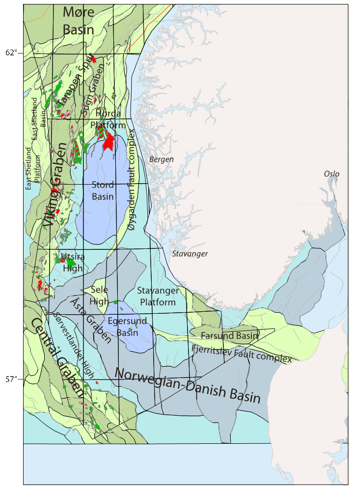
Fig. 2. Structural elements in the North Sea (NPD, Halland et al., 2011) with major oil- and gas fields.
A number of Triassic-Jurassic formations with sandy intervals are found throughout the North Sea, as evident in the lithostratigraphic column shown in figure 3. These units constitute important reservoirs and aquifers. Thick shale formations with good sealing capacity occur through both the Jurassic and Cretaceous sequences.
Much later, Early Cenozoic rifting took place with the onset of break-up of NE Atlantic and sea-floor spreading. A number of sub-marine fans were built from the Shetland Platform (a local source also existed in western Norway) due to uplift of basin margins. These sands interfinger with marine shales (Rogaland and Hordaland Groups), which constitute good seal rocks (see figure 3).
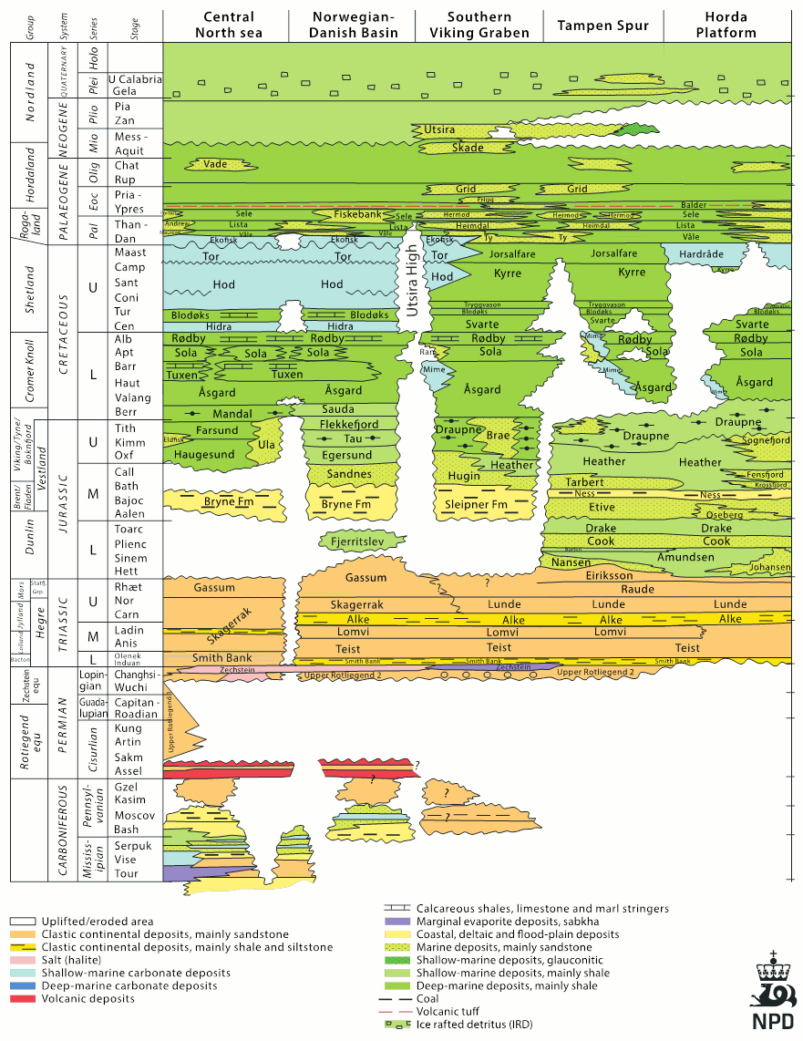 Fig. 3. Lithostratigrapic summary for the North Sea (NPD, Halland et al. 2011).
The Norwegian Sea
The mid-Norwegian margin consists of three segments, the Møre, Vøring, and Lofoten-Vesterålen segments, separated by the East Jan Mayen Fracture Zone and the Bivrost Lineament. Several tectonic (mostly extensional) episodes from late Palaeozoic to Palaeocene when Greenland and Eurasia started to separate have given rise to several basins with extensive sedimentation (Figure 4).
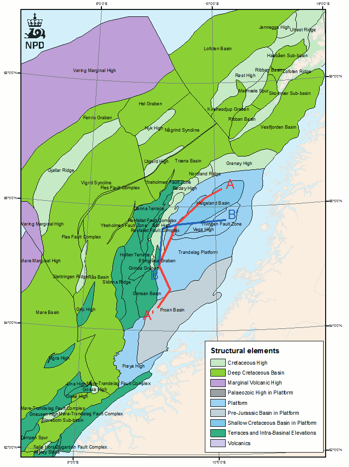
Fig. 4. Structural elements in the Norwegian Sea continental shelf (NPD, Halland et al., 2013)
The Trøndelag Platform is the inner eastern part of the Vøring segment and is considered the area with the best CO2 storage potential in the Norwegian Sea (NPD). The main formations with sand units suitable for CO2 storage are Åre, Tilje, Ile, and Garn. Good seals are found in Middle to Upper Jurassic shale formations like Ror, Not, Melke and Spekk (Figure 5).
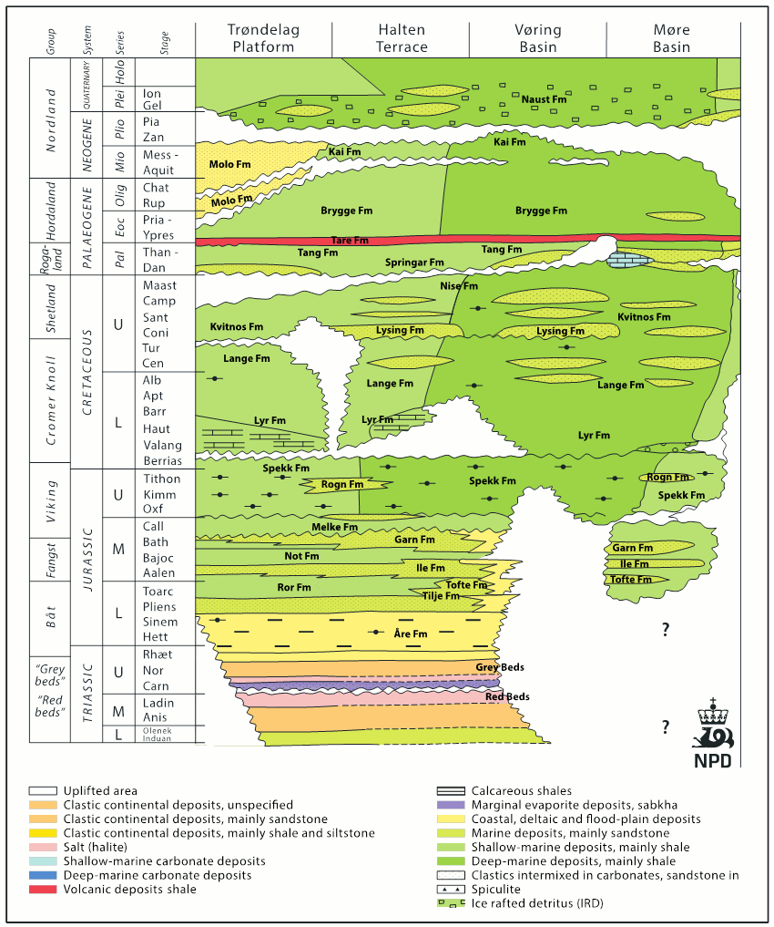
Fig. 5. Lithostratigrapic summary for the Norwegian Sea shelf area (NPD, Halland et al. 2013).
Formations with saline aquifers
The most prospective formations for CO2 storage in the North Sea and the Norwegian Sea (Figure 6a and 6b) are:
North Sea
- Statfjord Group (Uppermost Triassic–Lower Jurassic)
- Johansen and Cook Formations (Lower–Middle Jurassic)
- Bryne/Sandnes Formations (Middle–Upper Jurassic)
- Hugin East Formation (Middle–Upper Jurassic)
- Sognefjord East Formation (Upper Jurassic)
- Frigg Formations (Lower–Eocene) Depleted gas field
- Utsira (Upper Miocene–Lower Pliocene) and Skade (Lower Miocene) Formations
- Gassum Formation (Upper Triassic–Lower Jurassic)
Norwegian Sea
Åre and Tilje Formations (Upper Triassic–Lower Jurassic)
- Ile and Garn Formations (Middle Jurassic)
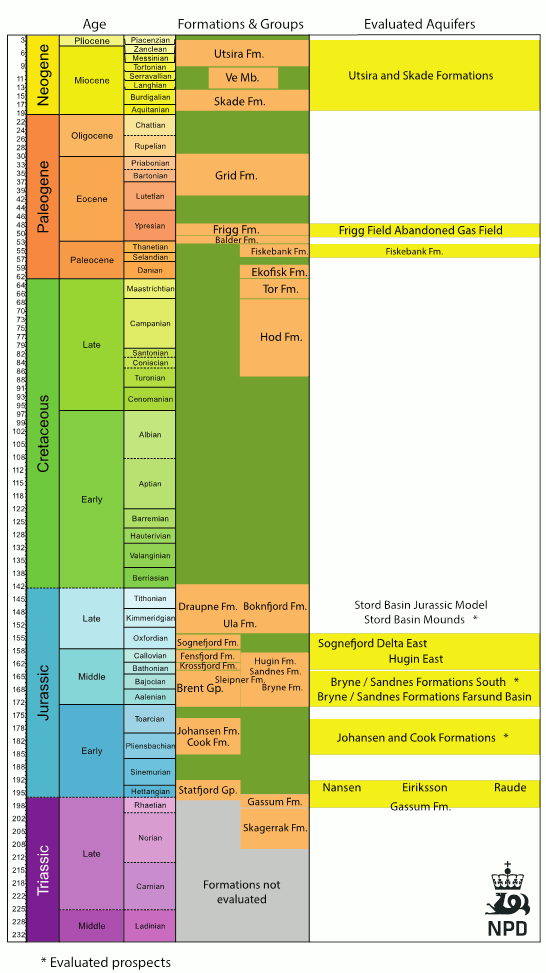
Fig. 6a. Main aquifers considered by NPD in the North Sea.
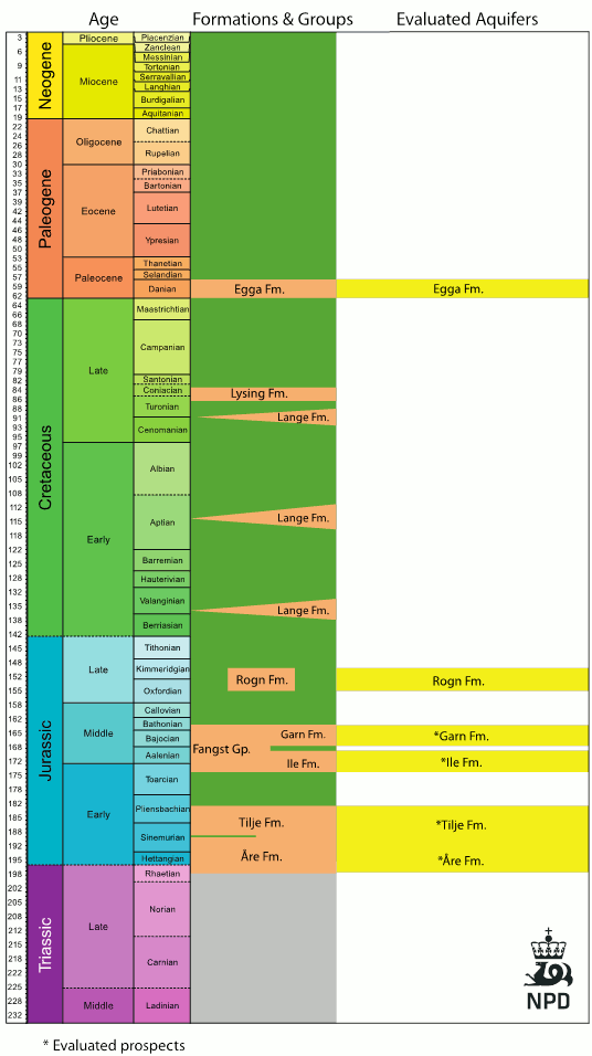
Fig. 6b. Main aquifers considered by NPD in the Norwegian Sea continental shelf.
North Sea
Statfjord Group (Uppermost Triassic–Lower Jurassic)
The Statfjord Group (upgraded from formation by Lervik, 2006) comprises the Raude, Eirikson and Nansen Formations deposited during Rhaetian to Sinemurian (Deegan & Scull 1977). It covers vast areas of the northern North Sea from the Øygarden Fault Zone, across Horda Platform, presumably extending into the Stord basin and thickening towards the Viking Graben and Shetland Basin (Halland et al. 2011)(Figure 1). The Statfjord Group is time-equivalent with the Gassum Formation.
In the Snorre Field at ~2300 m measured porosities are in the order of 16-28%, with a wide range of associated permeabilities between 250-4000 mD (Halland et al. 2011). Properties are expected to display large lateral variations in channel facies sandstones. The excistence of intra-formational mudstones deposited in a flood-plain environment have been known to cause challenges in hydrocarbon production (MacDonald & Halland, 1993). Mixed, layered lithologies may enhance CO2 spreading and dissolution (Sundal et al., 2014).
The Statfjord Group displays large thickness variations due to erosion and differential subsidence. In the type area Tampen Spur and on Horda Platform the total thickness is in the order of 140-320 m (Halland et al. 2011). The total estimated storage capacity is 1.8 Gt using a storage efficiency factor of 0.045. In comparison, Bøe et al. (2002) estimated a storage capacity of 8.4 Gt, and the NPD 4 Gt (Halland et al. 2011). The deviance is partly due to the application of a higher degree of heterogeneity and lower storage efficiency in this study.
Johansen and Cook Formations (Lower–Middle Jurassic)
The Johansen Formation sandstone is part of the Dunlin Group and was deposited during Sinemurian-Pliensbachian (Early Jurassic). It has been interpreted as a deltaic system, prograding east-west across the Horda Platform. The Johansen Formation is interfingering with marine mudstones of the Amundsen Formation. The Cook Formation is of Plienbachian-Toarcian age and may provide as a secondary storage unit depending on injection well location. In the Horda Platform area the Cook Formation is described as prograding shoreface sand deposits, locally influenced by tidal processes (Livbjerg & Mjøs 1989; Marjanac & Steel 1997; Charnock 2001). The sandy deposits of the Johansen Formation display estimated thicknesses in the order of 80-120 m. The secondary reservoir unit the Cook Formation is around 90 m thick.
In the cored well 31/2-3 for the Johansen Formation measured porosities range from 22-31%, with associated permeabilities up to 1500mD. Porosity models generated from acoustic impedance volumes indicate that porosities are preserved at 3 km depth. Calcite cemented layers (impermeable) are frequent, and may form flow baffles (Sundal et al. 2014). CO2 plume separation may enhance dissolution. In areas where the Cook Formation is inferred to provide as secondary reservoir modelled porosities are in the order of 6-15% (Gassnova, 2012). Vollset & Dore (1984) a net/gross sandstone/shale ratio of 0.8. The Johansen Formation is located at burial depths of 2-3 km on the Horda Platform. The theoretical storage capacity for the Johansen Formation is estimated to 0.9 Gt, given a storage efficiency factor of 0.03. Bøe et al. (2002) estimated a total storage capacity of 1.1 Gt and the NPD estimated 2 Gt (both including the Cook Formation).
Bryne/Sandnes Formations (Middle–Upper Jurassic)
The lower Jurassic (Bajocian to Bathonian) Bryne formation is present in the Norwegian-Danish Basin and in the Central Graben. It mainly consists of interbedded sandstones, siltstones, shales and coals, deposited in a deltaic/fluvial environment. Isolated channels are expected to affect lateral connectivity, whereas vertically coal layers may impede fluid flow (Halland et al. 2011). It is equivalent to the Haldager Sand Member (Danish shelf) (Vollset & Dore 1984).
The overlying, Callovian Sandnes Formation generally comprises cleaner, more continuous sandstones, deposited in a coastal/shallow marine environment (Vollset and Dore 1984; Halland et al. 2011). Burial depths are in the range of 1250-3500 m. The data base is limited and more extensive mapping should be performed. The NPD have proposed prospective storage sites in and close to the Farsund Basin and an overall storage capacity range of 14-16 Gt. The reservoir properties are considered suitable with average permeability in the order of 150 mD (Halland et al. 2011).
Hugin East Formation (Middle–Upper Jurassic)
The Early Bathonian to Early Oxfordian Hugin Formation is located in the southern Viking Graben. It comprises fairly sorted fine to coarse sandstones, commonly interlayered with shale and siltstones, and is interpreted as near shore, shallow marine deposits and in parts fluvial/deltaic (Vollset and Dore 1984). It displays thicknesses in the order of 50-170 m. NPD has identified prospective CO2 storage in Paleogene mounds (reservoir thicknesses 20-140 m) in the Stord Basin within a proposed deep marine fan system (Halland et al. 2011). But the data are uncertain and models are based mainly on 2D seismic and inferred porosities. There are no wells in the area.
Sognefjord East Formation (Upper Jurassic)
The Sognefjord Formation comprises a siliciclastic wedge covering the Horda Platform area in the northern North Sea. It was deposited in a shallow marine setting during the Jurassic rift phase (Oxfordian to Kimmeridgian) (Vollseth & Dorè 1984; Færseth 1996) and is the latest of three westward-prograding deltaic formations within the Viking Group (i.e. Krossfjord, Fensfjord and Sognefjord formations) (Steel 1993; Holgate et al. 2013; Patruno et al. 2015). The shallow marine sandstones are interfingering with the marine mudstone deposits of the Heather Formation representative of transgressive-regressive cycles (Steel 1993).
Measured porosities from wells in the Troll area are in the range of 19 to 34%, with associated permeabilities in the order of 1-1000 mD (Halland et al., 2011). Fine grained facies with high mica content is associated with lower permeability in parts (Johnsen et al. 1995; Bøe et al., 2002). The Sognefjord Formation is located at burial depths in the order of 1.5 – 2.5 km on the Horda Platform, down to 3.5 km in the Viking Graben. The theoretical storage capacity for the Sognefjord Formation is estimated to 11.4 Gt given a storage efficiency factor of 0.055. Bøe et al. (2002) estimated a total storage capacity of 2.5 Gt, whereas the 18 Gt estimate provided by NPD includes the underlying Krossfjord and Fensfjord formations.
Frigg Formation (Lower–Eocene)
The Frigg Formation is located offshore south-west Norway within the northern North Sea. The early Eocene sediments have been deposited as submarine fans triggered by gravity flows coming from the East Shetland Platform. The formation consists of poorly consolidated sandstones with lenses of silty claystone (npd.no).
The formation has a thickness of 279 m in the type well and 140 m in the reference well. The reservoir properties of the Frigg Formation are very good with porosities between 25 % and 32 % and high permeabilities varying between 900 mD and 3000 mD (norskolje.museum.no). The estimated CO2 storage capacity for the Frigg Formation is 1.2 Gt. NPD has studied CO2 injection into the abandoned gas field Frigg with and without a large connecting aquifer (Halland et al. 2011) and the storage capacity estimates are from 0.4 to 3.4 Gt CO2.
Skade Formation (Lower Miocene)
The Skade Formation is located offshore south-west Norway within the northern North Sea. The Lower Miocene – late Oligocene sediments have been deposited in an open marine environment as a response of a late Oligocene regression. The formation consists of fine to medium, occasionally coarse grained sandstones.
Pham et al. (2013) suggested an average porosity for the Skade sand of 32 % and an average horizontal permeability from 0.1 mD for shale/mudstone to 1000 mD for high permeable sands. The mean formation thickness is in the order of ca. 50-100 m (Isaksen & Tonstad 1989). In the Utsira High area the Skade and Utsira formations are not divided by a caprock unit and must be regarded partly as one aquifer (Bøe et al. 2002).
Utsira Formation (Upper Miocene–Lower Pliocene)
The Utsira Formation is located offshore south-west Norway within the northern North Sea. The Upper Miocene – Lower Pliocene sediments have been deposited in a large marine deltaic system which prograded towards the east. Depth to top reservoir varies between ca. 450 m and 1500 m. In the southern Viking Graben the Utsira Formation is 250-300 m thick and thins to 80-100 m thick sandy deposits in the northern Viking Graben.
Estimated and measured porosities range from 27 – 40 % (Chadwick et al. 2006). The weakly consolidated sandstone is very permeable with measurements varying between 1000–3000 mD (Arts et al. 2008). Reservoir performance is documented through CO2 injection at Sleipner since 1998 (Arts et al. 2008). Injectivity is high. Mudstone layers not visible until 4D seismic became available cause plume spreading and separation.
Norwegian Sea
Åre and Tilje Formations (Upper Triassic–Lower Jurassic)
The Rhaetian to Pliensbachian Åre Formation is located in the Norwegian Sea offshore mid-Norway. Thicknesses range between 300-500 m. It comprises alternating sandstones, coal and claystones, deposited in coastal plain to delta plain to marginal marine environments (Dalland et al. 1988). The overlying Sinemurian to Pliensbachian Tilje Formation is 100-150 m thick and comprises sandstones interbedded with shales and siltstones, deposited in nearshore marine to intertidal environments (Dalland et al. 1988). NPD estimates an average permeability of 140 mD and a storage capacity of 4 Gt given 0.7% storage efficiency (Halland et al. 2011).
Garn Formation (Middle Jurassic)
The Middle Jurassic (Bajocian to Bathonian) sandstones of the Gran Formation have been deposited in a near shore, wave dominated shallow marine environment along an N-S trending palaeo-coastline (Gjelberg et al. 1987; Corfield et al. 2001). The sandstones of the Garn Formation are medium to coarse grained, moderately to well-sorted interlayered by mica-rich zones.
In the Halten Terrace area measured porosities between 25 % and 34 % at a depth of 2.2 km. Permeability measurements in two wells (6406/3-2, 6406/3-1) give a broad variation from 1 mD to 1000 mD depending on lithology and burial depth (Ehrenberg & Boassen 1993). However, and average permeability of 400 mD is reported from NPD (Halland et al. 2014). The thickness of the Garn Formation in type well 6407/1-3 is 104 m but may increase up to ca. 150 m on the Trøndelag Platform (npd.no). Average net to gross from exploration wells is estimated to 0.85.
Formations with sealing properties
Typical rocks forming seals or caprocks of reservoirs/aquifers offshore Norway are mudstones, shales and fine-grained chalks. Shales, mudstones and siltstones (in addition to carbonates) constitute the major part of the sedimentary basins on the Norwegian shelf (See figure 3 and 5). They have normally quite wide regional extent, and they have good sealing capabilities. However, in certain areas, during salt tectonism and inversion, they may be eroded away. In addition, there are normally abundant secondary seals higher in the stratigraphy.
The sealing formations/groups for the most prospective aquifers identified are:
North Sea
The Dunlin Group
The Dunlin Group shales in the Amundsen and Drake Formation constitute the primary seal for both the Statfjord Formation and the Johansen Formation (Vollset and Doré 1984).
Amundsen Formation
The Amundsen Formation consists of light to dark grey marine siltstones and shales. It is split by the Johansen Formation, forming both the base and top of Johansen Formation. It has been deposited on a shallow marine shelf and is of Hettangian to Sinemurian (or Early Pliensbachian) age. It has a thickness of 40 to 130 m.
Drake Formation
The Drake Formation is a calcareous claystone of medium grey to dark colour. There may be sands developed within the formation. It was deposited within the pro-delta and delta-front environment during Toarcian to Bajocian time. It has reported thicknesses of 20 to 190 m. It is widely distributed, but thins out towards west and south.
Viking and Boknafjorden Groups
The mudstones of the Viking and Boknafjorden Groups are the primary seals of the Bryne/Sandnes/Hugin Formations (Vollset and Doré 1984).
Heather Formation
The Heather Formation is a grey silty claystone, in parts carbonaceous with limestone streaks. It is found over most of the northern North Sea, but has variable thickness. It is 30 m thick in the type well, but has thickness variations from 14 to 232 m in reference wells, and may get more than 1000 m thick in graben areas. The sedimentation took place in an open marine environment during Bathonian to Kimmeridgian time.
Draupne Formation
The Draupne Formation is a dark grey to black carbonaceous claystone was deposited in a marine environment with restricted bottom circulation, often with anoxic conditions. It has very good seal properties and is the most important source rock in the North Sea, with a wide extent, found in East Shetland Basin, Viking Graben, and Horda Platform. It is generally quite thick, with 163 m in the type well. It is of Oxfordian to Ryazanian age. The Draupne Formations (Viking Group) is also the primary seals for the Sognefjord Formation.
Hordaland Group
The Hordaland Group claystones seal the depleted gas field of the Frigg Formation. The Hordaland Group is a succession of Eocene to Early Miocene marine claystones with minor sandstones intervals (Frigg, Grid, Skade and Vade Formations). The claystones are generally grey to brown, and were deposited in an open marine environment in the North Sea Tertiary Basin. The Hordaland group reaches high thickness in central and southern part of the Viking Graben, with thicknesses of type wells of 1060 m and 1365 m.
Nordland Group
The Nordland Group mud- and claystones seal both the Utsira and Skade Formations. The group is dominated by marine claystones, covering Middle Miocene to recent strata (Deegan and Scull 1977). The Nordland Group has a large thickness, and is approximately 1000 m thick in the Viking Graben.
Norwegian Sea
Ror Formation
The Ror Formation is the primary seal for the Åre and Tilje Formations consists of dominantly grey to dark marine mudstones with some silty and sandy sequences, deposited in open shelf environments generally below wave base. It is found all wells in Haltenbanken, with thicknesses between 70 to 170 m (Dalland et al., 1988). It is of Pliensbachian to Toarcian age.
Not Formation
The Not Formation is a transgressional marine claystone separating the Ile and Garn Formations, forming the seal of the sandstones of Ile Formation. It is rather thin with a reported thickness of 14.5 min the type well and 37 m in the reference well. It is of Aalenian to Bajocian age (Dalland et al. 1988).
The Melke and Spekk Formations (Viking Group) are the seals for the Garn Formation (Dalland et al. 1988).
Melke Formation
The Melke Formation is a dark grey to dark brown claystone with some siltstone and limestone interbedding. It was deposited in an open marine environment, and being of Bajocian to Oxfordian age, it is correlated with the Heather Formation in the North Sea. It is found throughout Haltenbanken and Trænabanken, but can be absent on structural highs. It can be rather thick, but sub-crops in the eastern part of Trøndelag platform.
Spekk Formation
The Spekk Formation is a dark grey to dark brown organic rich shale deposited in marine anoxic bottom water. Has a large regional extent, but may be absent in structural highs. The formation is equivalent to the Draupne Formation in northern North Sea, and is of Oxfordian to Ryazanian age.
The total thickness of the Viking Group is considerable. There are in addition secondary sealing formations in the Cromer Knoll and Shetland groups.
References
Arts, RJ , A Chadwick, O Eiken, S Thibeau, S Nooner (2008) Ten years' experience of monitoring CO2 injection in the Utsira Sand at Sleipner, offshore Norway. First Break, 26, p.65-72
Bøe, R., Magnus, C., Osmundsen, P.T. and Rindstad, B.I. (2002) CO2 point sources and subsurface storage capacity for CO2 in aquifers in Norway. Geological Survey of Norway, 32, 27 pp.
Chadwick, R. A., Zweigel, P., Gregersen, U., Kirby, G. A., Holloway, S., Johannessen, P. N. (2004) Geological reservoir characterization of a CO2 storage site: The Utsira Sand, Sleipner, Northern North Sea. Energy 29 (9-10), pp. 1371-1381.
M.A. Charnock, I.L. Kristiansen, A. Ryseth, J.P.G. Fenton (2001) Sequence stratigraphy of the lower Jurassic Dunlin Group, northern North Sea. O.J. Martinsen, T. Dreyer (Eds.), Sedimentary Environments Offshore Norway – Palaeozoic to Recent: An Introduction, vol. 10Elsevier Science B. V., Amsterdam, Netherlands (2001), pp. 145–174
Dalland, A., Worsley, D. and Ofstad, K. (1988) A lithostratigraphic scheme for the Mesozoic and Cenozoic succession offshore mid- and northern Norway. NPD-Bulletin No 4, 36 pp
Deegan, C.E. and Scull, B.G. (1977) A standard lithostratigraphic nomenclature for the Central and Northern North Sea. NPD-Bulletin No 1, 64 pp
Faleide, J.I., Tsikalas, F., Breivik, A.J., Mjelde, R., Ritzmann, O., Engen, Ø., Wilson, J. And Eldholm, O. (2008) Structure and evolution of the continental
margin off Norway and the Barents Sea. Episodes 31, p 82-91.
Færseth, R. 1996. Interaction of Permo-Triassic and Jurassic extensio- nal fault-blocks during the development of the northern North Sea. Journal of the Geological Society 153, 931-944.
Gassnova (2012). Geological storage of CO2 from Mongstand. Interim report Johansen Formation. Andfossen, P.O., Horntvedt, L., Ravn, T., Rørvik, K.L., Diesen, M., Keaney, G., Torgersen, T.A., Vetaas, M.V., Erichsen, E., Mohr, J. (Eds.). Report TL02-GTL-Z-RA-000, available from Gassnova on request.
Halland, E. et al., 2011 CO2 storage atlas Norwegian North Sea
Halland, E. et al., 2012 CO2 storage atlas Norwegian Sea
Halland, E. et al., 2014 The CO2 Storage Atlas of the Norwegian Continental Shelf
Holgate et al., 2013 Holgate, N.E., Jackson, C.A.-L., Hampson, G.J. and Dreyer, T. (2013) Sedimentology and sequence stratigraphy of the Middle-Upper Jurassic Krossfjord and Fensfjord formations, Troll Field, northern North Sea. Petrol. Geosci., 19, 237–258.
Isaksen D. and Tonstad K. (1989). A revised Cretaceous and Tertiary lithostratigraphic nomenclature for the Norwegian North Sea. Norwegian Petroleum Directorate Bulletin, 5.
Johnsen, J. R., Rutledal, H., & Nilsen, D. E. (1995). Jurassic reservoirs; field examples from the Oseberg and Troll Fields: Horda Platform area Petroleum Exploration and Exploitation in Norway. (Vol. 4, pp. 199-234). Amsterdam: Elsevier.
Lervik, K.-S. (2006) Triassic lithostratigraphy of the northern North Sea Basin. Norwegian Journal of Geology, Vol. 86, p. 93-117.
Livbjerg, F., and Mjøs, R., 1989, The Cook Formation, an offshore sand ridge in the Oseberg area, northern North Sea, chapter 23, in Collinson, J.D., editor, Correlation in hydrocarbon exploration Correlation in Hydrocarbon Exploration:
MacDonald, A.C. and Halland, E.K. (1993). Sedimentology and shale modeling of a sandstone-richfluvial reservoir: Upper Statfjord Formation, Stafjord Field, northern North Sea. AAPG Bulletin, 77, p. 1016-1040.
Marjanac, T. and Steel, R.J. (1997) Dunlin Group Sequence Stratigraphy in the Northern North Sea: A Model for Cook Sandstone Deposition. AAPG Bulletin, v. 81, no. 2, p. 276–292.
Patruno, S., GJ Hampson, G.J., Jackson, CAL and T Dreyer, T. (2015)
Clinoform geometry, geomorphology, facies character and stratigraphic architecture of a sand-rich subaqueous delta: Jurassic Sognefjord Formation, offshore Norway. Sedimentology 62, 350-388
Pham et al. Pham, V.T.H., Riis, F., Gjeldvik, I.T., Halland, E.K., Tappel, I.M., Aagaard, P., (2013). Assessment of CO2 injection into the south Utsira-Skade aquifer, the North Sea, Norway, Energy, Volume 55, pp. 529-540.
Steel, R. J. (1993) Triassic–Jurassic megasequence stratigraphy in the northern North Sea: rift to post-rift evolution, in J. R. Parker, ed., Petroleum geology of northwest Europe: Proceedings 4th Conference London (1992), 1, Geological Society of London, p. 299–315.
Sundal, A., Miri, R., Ravn, T. and Aagaard, P. (2015) Modelling CO2 migration in aquifers; considering 3D seismic property data and the effect of site-typical depositional heterogeneities. International Journal of Greenhouse Gas Control 39, pp. 349-365.
Vollset, J. and Doré, A.G. (1984). A revised Triassic and Jurassic lithostratigraphic nomenclature for the Norwegian North Sea. NPD-Bulletin No 3, 53 pp
Ziegler, W.H., Doery, R. and Scott, J. (1986). Tectonic habitat of Norwegian oil and gas. In Spencer, A.M. et al. Habitat of Hydrocarbons on the Norwegian Continental Shelf (Norwegian Petroleum Society), p 3-19.
Sweden
Geological framework
The identified eight Swedish potential storage units are found in two areas in southern Sweden: the south-east Baltic Sea and south-west Scania. Each storage unit is located within a geological basin, which in the following text are described as individual geological units.
The south-east Baltic Sea
The sedimentary bedrocks of the south-east Baltic Sea belong to the Baltic Syneclise which is the largest structural element within the south-western margin of the East-European Craton (Brangulis et al., 1993), see figure 1. The Cambrian sediments were deposited in a relatively stable tectonic environment and as such, the sedimentation proceeded relatively slow and uniformly. More marine conditions prevailed in the eastern part of the area. The sedimentary formations within the Swedish economic zone are regional distributed towards the Baltic countries to the east and south-east. In the deepest parts in Sweden, the Baltic sedimentary succession measures more than 2000 m (Wik et al., 2005). Sediments of the south-east Baltic Sea area are gently dipping < 1° to the east-south-east. Only minor faults are identified in the Cambrian and Silurian sedimentary record.
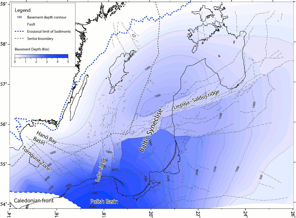
Figure 1. Map showing major structural elements in the south-east Baltic Sea (Sopher et al., 2014).
South-west Scania
South-west Scania belongs structurally to the eastern part of the Danish Basin. The basin is regionally distributed to the north and west, covering the Danish economic zone. In Sweden, the north-eastern margin of the basin more or less coincide with the Sorgenfrei Tornquist Zone and the Romeleåsen Fault Zone. The area south-west of the Sorgenfrei Tornquist Zone includes a thick cover of 1600–3000 m sedimentary rocks of Early Palaeozoic to Cenozoic age on top of the crystalline basement. The Skurup Platform is found east of the north-northeast to south-southwest trending Svedala Fault Zone and the Barsebäck Platform to the west. Structurally, the Barsebäck Platform is down fault to the Skurup Platform and is partly included in the Höllviken Halfgraben to the south-west (Figure 2). In south-west Scania, the Paleozoic and Triassic sedimentary succession is gently dipping towards the south-southwest whereas the following sedimentary succession is gently dipping 1-2° to the north-east towards the Romeleåsen Fault Zone.
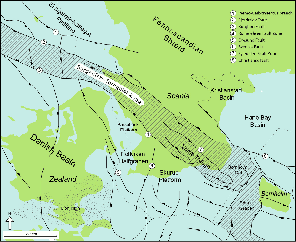
Figure 2. Map showing major structural elements in south-west Scania.
Formations with saline aquifers
The identified eight potential storage units in southern Sweden are all located in deep saline aquifers (Erlström et al., 2011, Mortensen, 2014). The south-east Baltic Sea and south-west Scania have both undergone seismic surveys and deep drillings, mainly in the 1970–80s, in relation to prospects for hydrocarbons by the Swedish Oil Prospecting Company, OPAB, and the Swedish Exploration Consortium, SECAB. Because of very limited findings, the explorations were not carried further on.
In the south-east Baltic Sea, two stratigraphic intervals with three potential storage units, including one trap, were identified:
· 2.1 File Haidar Formation (Early Cambrian) including the Viklau and När aquifers
· 2.2 Borgholm Formation (Middle Cambrian) including the Faludden aquifer and the Dalders structure
In south-west Scania, five stratigraphic intervals with five potential storage units were identified:
· 2.3 Ljunghusen Sandstone and Hammar Formation (Early Triassic) including the "Bunter Sandstone" aquifer
· 2.4 Höganäs Formation and Rya Formation (Late Triassic–Early Jurassic) containing the Höganäs-Rya aquifer
· 2.5 Lower Cretaceous sands (undefined stratigraphic interval) (Early Cretaceous) including the Lower Cretaceous sands aquifers (Unit A and B)
· 2.6 Arnager Greensand (Early Albian–Cenomanian) including the Arnager Greensand aquifer
According to reservoir properties, the Faludden, Arnager Greensand and Höganäs-Rya aquifers represent the most attractive storage units (Aagaard et al., 2014, Anthonsen et al., 2014). These three aquifers were also described in previous deliverable D25 (Lothe et al., 2014).
File Haidar Formation (Early Cambrian)
The sediments of the File Haidar Formation were deposited in Early Cambrian and has a total thickness of c. 100 m in the Gotland-Öland area, reaching a maximum of 127 m offshore in the deepest parts of the Basin. The File Haidar Formation consists of the Viklau Member, the När Shale Member and the När Sandstone Member (fig. 3). The oldest part (Viklau Member) of the File Haidar Formation is present in the south-east Baltic Sea area, the southern part of the Bothnian Sea and on the Swedish mainland. The younger parts (När Shale and När Sandstone Members) of the File Haidar Formation are only present in the south-east Baltic Sea area. In the south-east Baltic Sea area, the File Haidar Formation rests unconformably on the crystalline basement and is overlain by the Borgholm Formation in the eastern part of the area and by the Alum Shale Formation in the western part of the area. Biostratigraphy is mainly based on acritarch data (Nielsen & Schovsbo, 2007). The Viklau and När Sandstone Members are dominated by quartz sandstones whereas the När Shale Member is dominated by shale and siltstone. In general, the sediments were deposited in a transgressive basin with temporary periods of sea level lowstands where the sediment supply came from erosion of the coasts to the north and east (Siggerud, 2008).
Viklau Member
The Viklau Member is the oldest member of the File Haidar Formation and its sediments were deposited in Early Cambrian. The Viklau Member is resting unconformably on the crystalline basement with a conglomerate as its base and is overlain by the När Shale Member (Nielsen & Schovsbo, 2007). In the Baltic Sea area the Viklau Member is dominated by quartz sandstone in the upper and lower parts, whereas the middle part consists of bioturbated siltstone and shale. The sediments of the Viklau Member were deposited in a near shore environment in a temporary general sea level lowstand period. The member has an average thickness of c. 50 m and is exposed on the eastern margin of the Swedish mainland along the north-western margin of the sedimentary basin. Below the island of Gotland and basinwards, the member occurs at depths below 400 m (OPAB, 1976).
The Viklau aquifer represents an open saline aquifer gently dipping < 1° towards the east-south-east. In Sweden, the part of the Viklau Member which represents the identified aquifer is covering an area of c. 15000 km2 (Mortensen, 2014). Due to insufficient seismic data, no structural traps or highs have been identified, but as the sandstone units may occur as individual lenses of varying lateral distribution, some of these may act as local traps. Reservoir properties are poorly known and based on very few petrophysical logs and lithological descriptions (OPAB, 1976). Estimated porosity is set to 8% and permeability to 30 mD, although large lateral variation may be present. Estimated sand net/gross is set to 0.65 (Mortensen, 2014).
När Sandstone Member
The När Sandstone Member is the youngest member of the File Haidar Formation and its sediments were deposited in Late Early Cambrian. The När Sandstone Member rests conformably on the När Shale Member and is conformably overlain by the Grötlingbo Member of the Borgholm Formation (Nielsen & Schovsbo, 2007). The sediments of the När Sandstone Member were deposited in a temporary general sea level lowstand period in a near shore environment and is dominated by fine- and medium-grained quartz sandstone with local interbeds of clay- and siltstone. The member has an average thickness of c. 30 m and is exposed on the eastern margin of the Swedish mainland along with the north-western margin of the sedimentary basin. Below the island of Gotland and basinwards, the member occurs at depths below 300 m (OPAB, 1976).
The När aquifer represents a regional distributed open saline aquifer gently dipping < 1° towards the east-south-east. In Sweden, the part of the När Sandstone Member which represent the identified aquifer is covering an area of c. 15000 km2 (Mortensen, 2014). Due to insufficient seismic data, no structural traps or highs have been identified. Reservoir properties are poorly known and based on very few petrophysical logs and lithological descriptions (OPAB, 1976). Estimated porosity is set to 10% and permeability to 50 mD, although large lateral variation may be present. Estimated sand net/gross in the När aquifer is set to 0.65 (Mortensen, 2014).
Borgholm Formation (Middle Cambrian)
Sediments of the Borgholm Formation were deposited in Latest Early to Middle Cambrian and parts of the formation have a regional distribution from southern Bothnian Bay to south central Sweden and the south-east Baltic Sea area. The formation has a total thickness of more than 150 m in the south-east Baltic Sea area, where it comprises 3–5 members (fig. 3). As the storage unit of the Faludden Member pinches out between the islands of Gotland and Öland the focus of this report is limited to the part east of the pinch-out line. In this area, the Borgholm Formation comprises the Grötlingbo Member, the Mossberga Member and the Faludden Member. The Borgholm Formation rests conformably on the File Haidar Formation and is in the south-western part overlain by the Alum Shale Formation and in the northern and eastern parts by the Ordovician limestones. The biostratigraphical zonation is mainly based on trilobite and acritarch data (Nielsen & Schovsbo, 2007). The basal parts of the formation (Grötlingbo and Mossberga Members) are dominated by clay- and siltstones with local interbeds of sandstones, whereas the upper part (Faludden Member) is dominated by homogeneous quartz sandstone. In general, the sediment supply came from erosion of uplifted areas to the north and east (Siggerud, 2008).
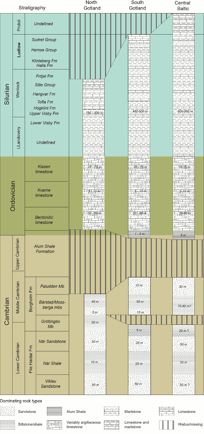
Figure 3. Schematic stratigraphic model for the Palaeozoic bedrock in the Swedish part of the south Baltic Sea, exemplified by subsurface information from wells on north and south Gotland, and in the Baltic Sea south of Gotland. Note that the Silurian lithostratigraphic subdivision is based on the bedrock of Gotland and not defined in the subsurface distal parts in the Baltic Sea. The model is based on information in Erlström et al. (2009, 2011) and Nielsen & Schovsbo (2007).
Faludden Member
The Middle Cambrian Faludden Member is dominated by clean, fine- and medium-grained quartz sandstone deposited in a near shore environment with a basinwards progradation towards west. Due to a relatively stable tectonic environment the sedimentation proceeded relatively slow and constant which resulted in a high homogeneity over a large area. Occasional interbeds of shale and siltstone reflects the distance to the shore together with fluvial and deltaic influences (Erlström et al., 2011). The Faludden Member is regionally distributed in the Baltic Syneclise and continues towards the south-east and the Baltic countries, here referred to as the Deimena Formation. To the north-west the Faludden Member pinches out along a north-northeast to south-southwest trending line between the islands of Gotland and Öland. The member has a large wedge-shaped distribution gently dipping < 1° to the east-southeast. Except from minor highs of 20–50 m amplitude, the Faludden Member has a relatively smooth upper surface (Erlström et al., 2011). Within the Swedish economic zone, the Faludden Member is present below c. 400 m depths beneath the island of Gotland and 1000 m depths in the deepest parts offshore. The Faludden Member has an average thickness of c. 10 m onshore and c. 45 m offshore (OPAB, 1976).
The Faludden aquifer represents a stratigraphically confined open saline aquifer, gently dipping towards the east-south-east. In Sweden, the part of the Faludden Member which represent the identified aquifer is covering an area of c. 11000 km2 (Erlström et al., 2011, Mortensen, 2014). Besides from minor highs, the aquifer contains one larger structural trap, the Dalders structure, which has undergone commercial prospecting for hydrocarbons, but data is not yet available. Reservoir properties are poorly known and based on petrophysical logs together with a few drill cores. Porosities are ranging from 8.2 to 20%, averaging 14%, and permeability measures are ranging from 0.7 to 1255 mD, averaging 147 mD (OPAB, 1976). Estimated sand net/gross is set to 0.90 (Mortensen, 2014).
Ljunghusen Sandstone and Hammar Formation (Early Triassic)
In Sweden, the Ljunghusen Sandstone and Hammar Formation are together equivalent to the Danish–German Bunter Sandstone Formation (Erlström & Sivhed, 2012). Hence, in the Swedish nomenclature in the NORDICCS project this storage unit is, for the sake of recognisability, also referred to as "Bunter Sandstone". However, in the following text the Swedish formal stratigraphy of the storage unit will be described separately (fig. 4). The Bunter Sandstone is in the Swedish economic zone limited to the Höllviken Halfgraben and distribution is by that defined by the Romeleåsen Fault Zone to the north-east, the Svedala Fault Zone to the east and the Öresund Fault to the west (fig. 2).
Ljunghusen Sandstone (Induan)
In the Höllviken Halfgraben, the Ljunghusen Sandstone represents the oldest part of the Bunter Sandstone and is only present in the deepest parts of the Höllviken Halfgraben. The sediment comprises well-sorted, reddish, medium- and coarse-grained quartz sandstone with interbeds of siltstone. The origin of the Ljunghusen Sandstone has been interpreted as eolian. The Ljunghusen Sandstone rests on a basal conglomerate of possibly Rotliegend age, and is overlain by the Hammar Formation with a gradual transition to more clayey matrix. As fossils are not present in the formation the age is not certain, though Induan age seems likely (Erlström & Sivhed, 2012).
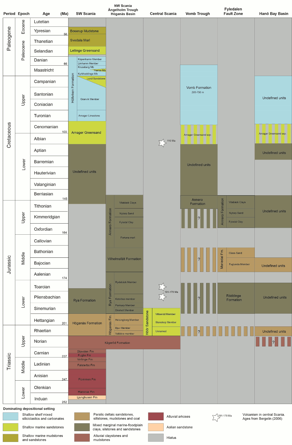
Figure 4. Schematic stratigraphic scheme of the Mesozoic and Cenozoic sedimentary bedrock in Scania. The scheme is based on information in Norling et al. (1993), Norling & Grigelis (1999), Sivhed et al. (1999), Erlström et al. (2004), Ahlberg et al. (2004), Bergelin (2006) and Erlström & Sivhed (2012).
Hammar Formation (Induan–Olenekian)
The Hammar Formation is only distributed within the Höllviken Halfgraben in south-west Scania. The formation rests on the Ljunghusen Sandstone, where present, or on the basal conglomerate of possibly Rotliegend age (Sivhed et al., 1999). The Hammar Formation is overlain by the Flommen Formation. The Hammar Formation consists of red and green fine-grained greywackes interbedded with red coarse-grained arkosic sandstone. Age is based on finds of palynomorphs and correlates with the Middle Bunter Sandstone in Germany (Erlström & Sivhed, 2012).
The Bunter Sandstone aquifer represents a partly fault confined semi-closed saline aquifer, gently dipping towards the south-southwest. In Sweden, the Bunter Sandstone aquifer is distributed over an area of c. 1100 km2, all within the Höllviken Halfgraben, at depths below 1500 m and deeper (Erlström et al., 2011, Mortensen, 2014). Total thickness of the aquifer is averaging 137 m. Reservoir properties are poorly known and based on petrophysical logs together with a few drill cores. Porosity is estimated from well reports and are ranging from 9 to 19%, averaging 12%, and permeability measures are ranging from 19 to 139 mD, averaging 59 mD (OPAB and SGU completion reports), although an estimated value of 300 mD is anticipated as reasonable (M. Erlström, pers.com.). Sand net/gross is estimated to 0.67 from well reports (Mortensen, 2014).
Höganäs Formation and Rya Formation (Rhaetian–Early Jurassic)
Sediments of the Höganäs and the Rya formations were deposited in the north-west and west of Scania during Late Triassic–Early Jurassic times in a near shore-deltaic environment. The formations consist of multi-layered sand- and claystone with interbeds of shale and coal. Sand bodies are wedge shaped with large, though local distribution, and individual sand intervals can be up to 20 m thick (Erlström et al., 2011). The sand sections in the Höganäs and Rya formations consist of fine-grained homogeneous quartz sand and have average porosities of 23% and average estimated permeability of c. 200 mD. The porosity and permeability data are based on analyses of drill cores and petrophysical log interpretations. Thickness of the Höganäs and Rya formations are c. 180 m and top of the Rya Formation is located at average depths of c. 1350 m. The sand net/gross is calculated to 51% from OPAB well reports, which gives an average net sand thickness of c. 92 m (Mortensen, 2014).
In Sweden, the part of the Höganäs Formation and Rya Formation which represent the identified aquifer is covering an area of c. 2100 km2 (Mortensen, 2014). The Höganäs-Rya aquifer continues across the Swedish economic zone towards Denmark where it is partly equivalent to the Danish Gassum Formation.
Höganäs Formation (Rhaetian–Hettangian)
The Höganäs Formation is characterised by near shore and deltaic deposits and comprises the Vallåkra Member, the Bjuv Member and the Helsingborg Member. In thickness, the Vallåkra and Bjuv Members comprise c. 1/4 of the Höganäs Formation. The sediments of the two members were deposited in Rhaetian and consist of clay- and sandstones, and the Bjuv Member is bordered at base and top by decimetre thick coal seams. The Helsingborg Member is dominating the Höganäs Formation and comprises c. 3/4 of the total thickness of the formation. The sediments of the Helsingborg Member were deposited in Hettangian and is dominated by cyclic repetitions of clay and sandstones. The Höganäs Formation rests on the Triassic Kågeröd Formation and is overlain by the Rya Formation in a transmission to more marine conditions (Sivhed & Wikman, 1986).
Rya Formation (Sinemurian–Aalenian)
The Rya Formation is characterised by more marine conditions and comprises the Döshult Member, the Pankarp Member, the Kastlösa Member and the Rydebäck Member. The formation, especially the Döshult and Kastlösa Members, includes a very rich marine fauna. The basal Döshult Member is the most sandy section whereas the clay content increases upwards in the formation. The Rya Formation rests on the Höganäs Formation and marks a transgressive period. Presence of the Rya Formation is uncertain in the south- western parts of the area whereas it in north-west Scania is well known and overlaid by the Vilhelmsfält Formation (Sivhed & Wikman, 1986).
Lower Cretaceous sands (Early Cretaceous)
The Lower Cretaceous sands is an informal, undefined unit with a regional distribution south-west of the Romeleåsen Fault Zone together with occurrence in the southern part of the Vomb Trough. The Lower Cretaceous sands consist of quartz sandstone interlayered with silt and claystone deposited in a shallow marine and marginal setting (Erlström, 1994). The Lower Cretaceous sands are resting on the Rya Formation in west and on the Late Jurassic Annero Formation in the Vomb Trough (Lindström & Erlström, 2011).
For the Lower Cretaceous sands, two saline aquifers have been identified and mapped: Unit A in south-west Scania comprising an open, partly fault confined, i.e. the Romeleåsen Fault Zone, saline aquifer covering an area of c. 5600 km2 on Swedish territory, and Unit B in the southern Vomb Trough comprising a semi-closed, fault confined saline aquifer covering an area of almost 300 km2. Thickness varies great from an average of 29 m in south-west Scania to c. 200 m in the Vomb trough. Porosity is averaging 25% and permeability is estimated to c. 200 mD. The estimated sand net/gross is set to 65% (Mortensen, 2014).
Arnager Greensand (Early Albian–Cenomanian)
The Arnager Greensand was deposited in a marine marginal setting during the Early Albian–Cenomanian. The formation has a regional distribution in south-west Scania, confined towards the north-east by the Romeleåsen Fault Zone and continuing towards the west and south in the Danish Basin across the German and Danish economic zones. The Arnager Greensand is also present in the Vomb Trough and Kristianstad Basin although in smaller and more uncertain content and at shallower depths. In Sweden, the formation is only known from a number of deep drillings whereas outcrops occur on the island of Bornholm in Denmark. In south-west Scania and adjacent sea, thickness of the Arnager Greensand varies from c. 20 m in the north-western part of the area to c. 60 m in the southern parts. In part of south-west Scania and the Vomb Trough, the Arnager Greensand rests on a thin layer of dark shales, probably of Aptian age, whereas in other parts of the distributional area, it rests on the undefined Lower Cretaceous sands (Lindström & Erlström, 2011). The overlying Arnager Limestone marks a sharp lithological change from the clastic greensands to a biomicritic limestone (Erlström, 1994).
The Arnager Greensand aquifer represents an open, partly fault confined, saline aquifer with a regional distribution gently dipping 1–2 degrees towards the north-east. The part of the formation suitable for CO2 storage is located south-west from the Romeleåsen Fault Zone and covers an area of almost 5200 km2 on Swedish territory (Mortensen, 2014). The storage unit contains no traps or closures (Erlström et al., 2011). The Arnager Greensand aquifer consists of poorly consolidated, fine- and medium-grained glauconitic quartz sandstone. Porosity is averaging 26% and permeability is estimated to c. 400 mD, but more than 1 D has been measured (Erlström et al., 2011). The estimated sand net/gross is set to 80% (Mortensen, 2014).
Formations with caprock properties (seal)
Storage of CO2 is dependent not only on the properties of the reservoir but also on the integrity of the sealing formation. Geological formations in Sweden with sealing properties are mainly marine, more or less clayey carbonates. Intermediate seals also occur as relatively thin beds of shales and complete formations dominated by shale or claystone, see stratigraphic schemes in figure 3 and 4. Furthermore, interbedded clay- and mudstones can act as local seals in multilayered aquifers as the Höganäs-Rya aquifer. Leakage may take place through the caprock due to slow capillary migration, through micro-fractures or along faults. Detailed site characterisations are needed in order to test the integrity of the seal at future storage sites.
In the south-east Baltic Sea two primary caprocks are present:
· 3.1 Ordovician limestones
· 3.2 Silurian marlstones
In south-west Scania and the Vomb Trough, the primary caprocks are:
· 3.3 The Höllviken Formation (Turonian–Danian)
· 3.4 The Vomb Formation (Coniacian–Maastrichtian)
Ordovician limestones
In the Gotland-Baltic Sea area the Ordovician limestones have an informal division introduced by OPAB. From bottom the units are: the Bentonitic limestone, the Kvarne limestone and the Klasen limestone. The Bentonitic limestone rests on the Alum Formation, when present, or directly on the Faludden Member in the easternmost part of the area. Thickness of the Bentonitic limestone is approximately 50 m, thickening towards the east-southeast, and it comprises a argillaceous limestone with layers of bentonite. Porosities of up to 2–3%, mainly vugs and fractures, has been measured and a low vertical conductivity exists (Sivhed et al., 2004, Erlström et al., 2011). The Bentonitic limestone is overlaid by the Kvarne limestone with a thickness of only a few metres. The Kvarne limestone consists of dense clay interbedded with layers of micro crystalline limestone. Measured porosity is insignificant (Erlström et al., 2011). Topmost in the sequence of Ordovician limestones is the Klasen limestone comprising argillaceous limestones with thin beds of shales and reefal mounds (Sivhed et al., 2004). Thickness of the Klasen limestone is up to 64 m and averaging c. 35 m upon the Faludden aquifer. The Ordovician limestones in the Gotland-Baltic Sea area were deposited in a shallow marine environment with changing sea levels. The caprock is continuously distributed upon the area of the Faludden aquifer, and outcropping to the west at the island of Öland where the thickness is only 5-20 m. Estimated sand net/gross is set to 0%.
Silurian marlstones
Thickness of the Silurian bedrock varies from c. 300 to almost 900 m in the area, whereas the average thickness upon storage units is c. 625 m. The Silurian bedrock stratigraphy is based on topostratigraphical grounds, i.e. both biostratigraphy and lithostratigraphy (Erlström et al., 2009). The Silurian bedrock in the Gotland-Baltic Sea area is divided into 19 different formations, whereas 13 of the formations are gathered into 3 different groups. In the stratigraphic scheme in figure 3 the stratigraphic groups are listed when occurring. The Silurian sequence is resting on the Ordovician limestones and except from the basal undefined Llandovery part, all Silurian formations are exposed on the island of Gotland. Lithologically, the Silurian bedrock is dominated by marlstones with interbeds of limestones and siltstones deposited in a near-shelf marine environment. Even though minor faults and lineaments occur frequently in the Silurian bedrock, the rocks are only little affected by larger tectonic disturbances (Erlström et al., 2009). The Silurian caprock is continuously distributed upon the area of the Faludden aquifer. Estimated net/gross is set to 8%.
Höllviken Formation (Turonian–Danian)
The primary caprock for the south-west Scania aquifers is the Höllviken Formation representing a 900–1700 m thick sequence of argillaceous limestone and chalk with interbeds of clay and silt-/sandstone where chalk and limestones dominate towards the south-west (Sivhed et al., 1999). The Höganäs Formation is distributed throughout south-west Scania and adjacent offshore areas. The sand net/gross ratio varies great, mostly due to thick beds of silt- and sandstones, and is estimated to 9%. The Höganäs Formation is divided into eight members whereas two, the Lund Sandstone and Hansa Member, are dominated by sandstones. The Höganäs Formation was determined on lithostratigraphy based on well data and seismics (Erlström, 1994). The basal Arnager Limestone is resting on the Arnager Greensand and the topmost København Member is overlaid by the Lellinge Greensand. In the north-western Landskrona area, the København Member is transformed into the more sandy Landskrona Member. The København Member as well as the Limhamn Member is exposed in the area south of the Romeleåsen Fault Zone. Sediments of the Höllviken Formation were deposited under a transgressive period in a stable marine setting. Periodical increased sedimentary influxes from eroded areas north-east of the Romeleåsen Fault Zone gave rise to the sandy members (Sivhed et al., 1999).
The Vomb Formation (Coniacian–Maastrichtian)
The Vomb Formation is restricted to the Vomb Trough and is the primary caprock for the Lower Cretaceous sands in the same area. The formation includes the Arnager Limestone Member in the basal 70 m of the section and the average thickness of rest of the formation is c. 600 m. The Vomb Formation is overlying a sequence of arenaceous claystones and unconsolidated glauconitic siltstones, possibly belonging to the Arnager Greensand, and is outcropping as an eroded bedrock surface. The formation comprises siliciclastic limestones, silt- and sandstones, marlstones and claystones grading into each other interbedded with conglomerates and coal beds. Bioturbation is common and the stratigraphy is based on a rich marine fossil fauna. The sediments of the formation were deposited in a shallow marine setting with a relatively high clastic influx (Erlström, 1994). The high clastic influx is reflected in the estimated sand net/gross set to 60%.
References
Aagaard P, Anthonsen KL, Bergmo P, Mortensen GM, Snæbjörnsdottir SÓ, 2014. Screening and ranking of aquifer formations, storage units and traps. NORDICCS technical report D 6.2.1301.
Ahlberg, A., Sivhed, U. & Erlström, M., 2003. The Jurassic of Skåne, southern Sweden. I: F. Surlyk & J.R. Inesson: The Jurassic of Denmark and Greenland. Geology of Greenland Survey Bulletin 186:7–10, 1–15.
Anthonsen KL, Aagaard P, Bergmo P. E. S., Gislason S. R., Lothe A. E., Mortensen G. M., Snæbjörnsdottir S. Ó., 2014. Characterisation and selection of the most prospective CO2 storage sites in the Nordic region. Energy Procedia 63 (2014) 4884-4896.
Bergelin, I., 2006. 40Ar/39Ar geochronology of basalts in Scania, S Sweden: evidence for two pulses at 191–178 Ma and 110 Ma, and their relation to the breakup of Pangea. Examensarbeten i Geologi vid Lunds Universitet – Berggrundsgeologi 205, 1–28.
Brangulis, A.P., Kanev, S.V., Margulis, L.S. & Pomerantseva, R.A., 1993. Geology and hydrocarbon prospects of the Paleozoic in the Baltic region. Petroleum Geology '86 Ltd, 651–656.
Erlström, M., 1994. Evolution of Cretaceous sedimentation in Scania. Lund Publications in Geology, No 122.
Erlström, M., Sivhed, U., Wikman, H. & Kornfält, K-A., 2004. Beskrivning till berggrundskartorna 2D Tomelilla NV, NO, SV, SO, 2E Simrishamn NV, SV, 1D Ystad NV, NO, 1E Örnahusen NV. SGU ser Af 212–215.
Erlström, M., Persson, L., Sivhed, U. & Wickström, L., 2009. Beskrivning till regional berggrundskarta över Gotlands län. SGU serie K 221.
Erlström, M., Fredriksson, D., Juhojuntti, N., Sivhed, U. & Wickström, L., 2011. Lagring av koldioxid i berggrunden ─ krav, förutsättningar och möjligheter. SGU Rapporter och meddelanden 131.
Erlström, M. & Sivhed, U., 2012. Pre-Rhaetian Triassic strata in Scania and adjacent offshore areas ─ stratigraphy, petrology and subsurface characteristics. SGU Rapporter och meddelanden 132, 1–54.
Grigelis, A. & Norling, E., 1999. Jurassic geology and foraminiferal faunas in the NW part of the East European Platform, A Lithuanian – Swedish geotraverse study. SGU serie Ca 89, 1–101.
Lindström, S. & Erlström, M., 2011. Basin analysis of the uppermost Triassic to Lower Cretaceous, Danish Basin, Biostratigraphy and log correlation. GEUS Rapport 2011/82.
Lothe, A.E., Emmel, B.U., Bergmo P. E. S., Mortensen G. M., Frykman P., 2014. A first estimation of storage potential for selected aquifer cases. NORDICCS technical report D 6.3.1302 (D25).
Mortensen, G.M., 2014. CO2 Storage Atlas for Sweden - a contribution to the Nordic Competence Centre for CCS, NORDICCS. 31st Nordic Geological Winter Meeting, Lund, 2014.
Nielsen, A.T. & Schovsbo, N.H., 2007. Cambrian to basal Ordovician lithostratigraphy in southern Scandinavia. Bulletin of the Geological Society of Denmark, Vol. 53, pp. 47–92.
Norling, E., Ahlberg, A., Erlström, M. & Sivhed, U., 1993. Guide to Upper Triassic and Jurassic geology of Sweden. SGU serie Ca 82, 1–71.
OPAB, 1976: Baltic Sea, Exploration activities 1971-1976. Geology and Petroleum prospects.
OPAB, 1976: Gotland, Exploration activities 1972-1976. Geology and Petroleum prospects.
Siggerud, E.I.H., 2008. Sedimentology Early to Late Cambrian within the Dalders Prospect; Central Baltic Sea. In-house report to Svenska Petroleum Exploration AB.
Sivhed, U. & Wikman, H., 1986. Beskrivning till berggrundskartan HELSINGBORG SV. SGU serie AF, Nr 149.
Sivhed, U., Wikman, H. & Erlström, M. 1999. Beskrivning till berggrundskartorna 1C Trelleborg NV och NO samt 2C Malmö SV, SO, NV och NO. SGU serie AF, Nr 191, 192, 193, 194, 196, 198.
Sopher, D., Juhlin, C. & Erlström, M., (2014). New insights into the structure and stratigraphy of the Swedish sector of the Baltic Sea sedimentary Basin from vintage 2D marine seismic data. Geophysical Research Abstracts, Vol.16, EGU2014-10633, 2014.
Wik, N-G., Bergström, U., Bruun, Å., Claeson, D., Jelinek, C., Juhojuntti, N., Kero, L., Lundqvist, L., Stephens, M.B., Sukotjo, S. & Wikman, H., 2005. Beskrivning till regional berggrundskarta över Kalmar län. SGU serie Ba 66.